

Dachstein circular trail


- pets allowed
- Glacier region
- culturally interesting
- Multi-day tour
- Flatly
- Possible accommodation
Interactive elevation profile
Create PDF
Tour-Details
Paths covering:
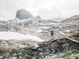
The Dachstein forms the imposing center of this circular hiking trail. In 8 stages you hike the mountains around the mountain personality Dachstein. On this unique and varied hiking tour you get to know the special features of the regions around the Dachstein. This circular tour leads from the Dachstein Salzkammergut - Tennengau - Filzmoos - Schladming Dachstein and all the way to the Ausseerland. Very special hiking huts are on the list of overnight stays. Tipp: Offers for hiking from hut to hut with luggage transfer
Unique hiking experience for real mountain enthusiasts
The description of the Dachstein Circumnavigation is given in the guide in an anti-clockwise direction, as both the scenic highlights and the differences in altitude fit more harmoniously into the route in this way. Starting in the north-west at Lake Gosau, continue along the foot of the Gosaukamm and the south faces of the Dachstein to Ramsau. From there you hike one level higher over the glacier to the east to the Guttenberghaus and on to the Stoderzinken. Through the Notgasse and Viehbergalm, the lonely plateau is crossed northwards in the footsteps of pilgrims to the Salzkammergut. On level paths, always along the River Traun, the route crosses the Salzkammergut, passing Bad Aussee, Obertraun, Hallstatt and Bad Goisern. Last but not least, you cross the Kalmberg mountains with the Goiserer Hütte on the way to Gosau.The stages of the Dachstein circular hiking trail:
1. Gosausee - Hofpürglhütte:
On the Austriaweg at the foot of the Gosaukamm to the Hofpürglhütte below the Bischofsmütze
2. Hofpürglhütte - Dachstein Südwandhütte:
Linzerweg and Pernerweg - under the spell of the Dachstein south faces, so to speak
3. Dachstein-Südwandhütte - Hunerkogel - Guttenberghaus:
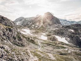
High up on the glacier hike across the landscape "am Stein"
4. Guttenberghaus - Stoderzinken:
About the alpine pastures on the Stein to the viewing summit of Stoderzinken
5. Stoderzinken - Bad Mitterndorf:
Through the Notgasse, Viehbergalm and lonely peaks to the Steinitzenalm or Bad Mitterndorf
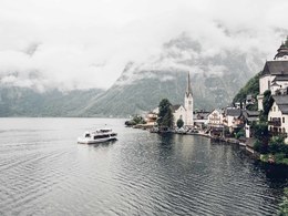
6. Bad Mitterndorf- Hallstatt:
Level paths along the stream: moors, karst springs, quiet forest lakes on the Salzkammerweg to Hallstatt
7. Hallstatt - Bad Goisern:
On the east bank hiking trail along the shore of Lake Hallstatt to Bad Goisern, a leisurely tour through the fjord-like valley.
8th Bad Goisern - Gosau:
On steep paths via the Goisererhütte to Gosau
Order hiking maps for the Dachstein Salzkammergut region ...
To the overview
Experience a 360° panoramic tour through the Gosau Valley...
Mountain rescue: 140
further information:
- Glacier region
- Multi-day tour
- Flatly
- Possible accommodation
- Board possible
This way is, depending on the weather, accessible from June till September.
by car
from Salzburg:
Motorway exit Golling via B162 Abtenau and B166 to Gosau
from Linz:
Motorway exit Regau on Salzkammergut street B145 towards Gmunden and Bad Ischl to Bad Goisern, in Bad Goisern turn right onto B166, at the Gosaumühle junction turn right towards Gosau
from Vienna/Graz:
Motorway exit Liezen on the B320, in Trautenfels turn on Salzkammergut street B145 to Bad Aussee, turn on Koppen street through Obertraun and Hallstatt, at the Gosaumühle junction turn left towards Gosau
from Villach:
Tauern motorway to exit “Eben im Pongau”, via the B166 Pass Gschütt federal road to Gosau
by train
Attnang-Puchheim - Stainach-Irdning lines
Arrival by train in "Steeg / Gosau" then continue with bus 541/542 in the direction Gosausee
By bus
Bus 470 (Abtenau - Gosau) direction Gosau, stop Gosau Abzw. Pass Gschütt
Bus 541/542 (Bad Ischl - Gosausee) direction Gosausee, stops Haltestelle: Gosau Klaushof, Gosau Bärnausiedlung, Gosau Ressenbachweg, Gosau Vordertal B166, Gosau Ramsau B166, Gosau, Gemeindeamt, Abzw. Pass Gschütt, Gosau Wirtsweg, Gosau Leitenweg, Gosau Schüttmannweg, Mittertal b. Gosau Ort, Mittertal, Hornspitzlift, Hintertal b. Gosau Falmbach, Hintertal b. Gosau Mühlradl, Hintertal b. Gosau Ort, Hintertal b. Gosau Madlgasse, Hintertal b. Gosau Schmiedweg, Hintertal b. Gosau Freilichtmuseum,Hintertal b. Gosau Zwieselalmbahn (Panoramajet), Hintertal b. Gosau Gosaukammbahn
Detailed information on the respective train and bus times can be found at https://www.oebb.at/en/ (train) and https://www.postbus.at/en(bus).
- Parking space: 516
- Parking area for disabled: 2
- Bus parking space: 7
According to the notice
E-service station / recharging station- Charging point for electric cars (fees apply)
- Free entry
- Suitable for groups
- Pets allowed
- Suitable for friends
- Suitable for couples
- Summer
Please get in touch for more information.

Gosauseestraße 5
4824 Gosau
Phone +43 5 95095 - 20
Fax machine +43 5 95095 - 74
E-Mail gosau@dachstein-salzkammergut.at
Web www.dachstein-salzkammergut.at
Web www.wandern-dachstein.at
https://www.wandern-dachstein.at
You can also visit us on
Visit us on Facebook Visit us on Instagram Visit us on Pinterest Visit our videochannel on YouTube WikipediaInteractive elevation profile
Create PDF
Tour-Details
Paths covering: