© Photo: Oberösterreich Tourismus GmbH./Robert Maybach: Enjoy the view in Upper Austria


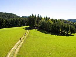
S3 Stifter Panoramaweg


- Suitable for kids (all ages)
- Flatly
Interactive elevation profile
Create PDF
Tour-Details
Path number: S3
Starting place: 4170 St. Stefan-Afiesl
Destination: 4170 St. Stefan-Afiesl
duration: 1h 21m
length: 4,4 km
Altitude difference (uphill): 131m
Altitude difference (downhill): 132m
Lowest point: 808m
Highest point: 922m
difficulty: easy
condition: medium
panoramic view: Dreamtour
Paths covering:
Hiking trail
powered by TOURDATA
Hiking in the footsteps of Adalbert Stifter: Numerous display boards along the way give an insight into the life and work of Adalbert Stifter and the time at that time.
Map download: S3 Stifter Panoramaweg
Starting point: Ortsplatz St. Stefan-Afiesl
Destination: Ortsplatz St. Stefan-Afiesl
further information:
- Flatly
- Board possible
General price information
free
- Suitable for kids (all ages)
- Spring
- Summer
- Autumn
Please get in touch for more information.
Hauptplatz 19
4190 Bad Leonfelden
Phone +43 5 07263 - 101
Fax machine +43 7213 6397 - 13
E-Mail badleonfelden@muehlviertel.at
Web www.muehlviertel.at
https://www.muehlviertel.at
")
")


")
Interactive elevation profile
Create PDF
Tour-Details
Path number: S3
Starting place: 4170 St. Stefan-Afiesl
Destination: 4170 St. Stefan-Afiesl
duration: 1h 21m
length: 4,4 km
Altitude difference (uphill): 131m
Altitude difference (downhill): 132m
Lowest point: 808m
Highest point: 922m
difficulty: easy
condition: medium
panoramic view: Dreamtour
Paths covering:
Hiking trail
powered by TOURDATA