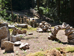
© Photo: Oberösterreich Tourismus GmbH./Robert Maybach: Enjoy the view in Upper Austria
Buchberg Kurzstrecke


- pets allowed
- All weather
- Suitable for families
- culturally interesting
- Flatly
- Possible accommodation
Interactive elevation profile
Create PDF
Tour-Details
Starting place: 4291 Lasberg
Destination: 4291 Lasberg
duration: 1h 50m
length: 5,1 km
Altitude difference (uphill): 270m
Altitude difference (downhill): 271m
Lowest point: 558m
Highest point: 809m
difficulty: easy
condition: easy
panoramic view: Some Views
Paths covering:
Asphalt, Gravel, unfixed, Hiking trail
powered by TOURDATA
The hike is moderately uphill until the last short steep section to the Hoh-Haus on the Buchberg. Good footwear and surefootedness are recommended.
You are welcome to pick up a hiking map from the Lasberg market town office or information material from the surrounding restaurants, which will guide you to the Hoh-Haus am Buchberg, as the individual hiking trails are well signposted.You start at the Lasberg market square and follow the signs La 3.8, past the Hofer inn in the direction of Etzlstorfer-Häusl. Then cross a side road and follow the path La 5,8,9 to the Hoh-Haus am Buchberg.
To return, follow the number 170 and turn right at the next fork (La 8) and return to the Lasberg market square via the Kernlandmuseum Spiralschmiede on path La 10.
Possible at any time. However, the hiking trails are not cleared in winter. It is advisable to pack snowshoes.
Accessibility / arrival
You will find plenty of parking spaces on the market square or behind the music school.
- All weather
- Suitable for groups
- Suitable for schools
- Suitable for kids (3 - 6 Year)
- Pets allowed
- Suitable for families
- Spring
- Summer
- Autumn
- Early winter
Please get in touch for more information.
Hauptplatz 14
4291 Lasberg
Phone +43 7947 7255 - 13
mobile +43 664 2308273
E-Mail marktgemeinde@lasberg.at
Web www.buchberg-hoh-haus.at/
Web www.lasberg.at
http://www.buchberg-hoh-haus.at/
http://www.lasberg.at
http://www.lasberg.at
You can also visit us on
WikipediaInteractive elevation profile
Create PDF
Tour-Details
Starting place: 4291 Lasberg
Destination: 4291 Lasberg
duration: 1h 50m
length: 5,1 km
Altitude difference (uphill): 270m
Altitude difference (downhill): 271m
Lowest point: 558m
Highest point: 809m
difficulty: easy
condition: easy
panoramic view: Some Views
Paths covering:
Asphalt, Gravel, unfixed, Hiking trail
powered by TOURDATA

