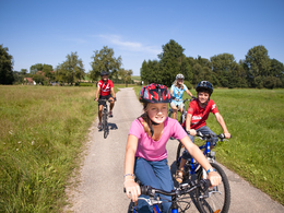
© Photo: Oberösterreich Tourismus GmbH./Robert Maybach: Enjoy the view in Upper Austria


Wander und -Raderlebnis am Granatzweg


Interactive elevation profile
Create PDF
Tour-Details
Starting place: 4922 Geiersberg
Destination: 4922 Geiersberg
duration: 5h 37m
length: 20,9 km
Altitude difference (uphill): 284m
Altitude difference (downhill): 284m
Lowest point: 408m
Highest point: 551m
difficulty: easy
condition: easy
panoramic view: Some Views
Paths covering:
Hiking trail
powered by TOURDATA
Before the Innviertel region became part of Upper Austria in 1779, the border with Bavaria ran along the ridges between Geiersberg and Taiskirchen. The Granatzweg follows this historic border.
The name "Granatz" comes from "granica", the Old Slavic word for border. There are several ways to discover this beautiful region around Pram, on foot and by bike.From Geiersberg to Taiskirchen
The starting point for the trail, which was opened in May 2010, is the small village of Geiersberg. The Granatzweg is not a circular tour, but there are several ways to get back to the starting point. One is on foot - with new viewpoints in the opposite direction - another is by taxi (Taxi Stiglbrunner: Tel. 07736 6273, 10 euros/ride). There are also a number of other route options (see map), so you can put together your own personal tour depending on your time and interests. The route through the hilly landscape of the Hausruck region is always varied. At the viewing platform in Gerhartsbrunn, the view is unobstructed in all directions. Display boards along the way provide interesting information on geological features and the history of the region. An art mile, a historical boundary stone and play stations for children round off the attractions.
Travelling by bike
The Granatzweg is also signposted as a cycle path and is almost effortless to cycle. There is a nice spot at the end of the trail at the Kapuzinerbankerl in Taiskirchen. From here we have chosen a low-traffic route back to Pram. The route leads down to the Pram reservoir. After going halfway round it to the right, you turn right up to the small village of Asbach and on to Pram. After a detour to Feldegg Castle, the Furthmühle mill museum takes us back to times gone by. From here there are several ways back to the starting point, we chose the one via Wirt z'Gries and did not regret it. Route length: 22 kilometres
Circular hike on the Granatzweg south route
A new and varied hiking trail - the Granatzweg Südroute - was opened in May 2011. Starting from the parish church in Pram, this 2 to 3 hour circular route leads over the Schulterberg to the Wirt z'Gries. From there it continues to the boundary stone in Rühring and past the tree house and the art mile to the viewing platform in Gerhartsbrunn. On the way down to Pram, you can make a detour to the beautiful Renaissance Feldegg Castle.
Arrival: on the Innkreis motorway
Characteristics: panoramic, well signposted hike and cycle tour with several variants, interesting stops with information boards
Times & altitudes
Walking time: 2 - 4 hours, depending on the route chosen
Pure cycling time: 1 hour 30 minutes, distance: 22 km, total metres in altitude: 250
Geiersberg (554 m) - Kapuzinerbankerl/Taiskirchen (520 m) - Pram (435 m)
Refreshments: Inns in the villages,
Tip: Wirt z'Gries, time-honoured inn in a quiet location with a beautiful garden, down-to-earth snacks, closed on Mondays and Tuesdays, Tel.: +43 (0)7732/2020, http://www.wirt-gries.at
Map: Compass No. 201
Info: http://www.granatz.at - http://www.furthmuehle.at - http://www.schloss-feldegg.at
Book tip:
Neuweg/Peham: Genuss-Biken in Oberösterreich, OÖNachrichten Edition by Trauner Verlag, Linz 2010 ISBN 978-3-85499-741-2
Most economical season
- Spring
- Summer
- Autumn
Please get in touch for more information.
4922 Geiersberg
Phone +43 7732 2151
E-Mail gemeinde@geiersberg.ooe.gv.at
Web www.oberoesterreich.at/geiersberg
http://www.oberoesterreich.at/geiersberg
Interactive elevation profile
Create PDF
Tour-Details
Starting place: 4922 Geiersberg
Destination: 4922 Geiersberg
duration: 5h 37m
length: 20,9 km
Altitude difference (uphill): 284m
Altitude difference (downhill): 284m
Lowest point: 408m
Highest point: 551m
difficulty: easy
condition: easy
panoramic view: Some Views
Paths covering:
Hiking trail
powered by TOURDATA