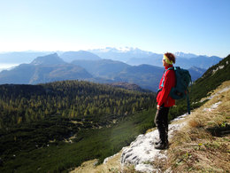
© Photo: Oberösterreich Tourismus GmbH./Robert Maybach: Enjoy the view in Upper Austria


Hohe Schrott


- Flatly
Interactive elevation profile
Create PDF
Tour-Details
Starting place: 4802 Ebensee
Destination: 4802 Ebensee
duration: 9h 27m
length: 18,4 km
Altitude difference (uphill): 1.594m
Altitude difference (downhill): 1.562m
Lowest point: 438m
Highest point: 1.781m
difficulty: difficult
condition: difficult
panoramic view: Great panorama
Paths covering:
Hiking trail
powered by TOURDATA
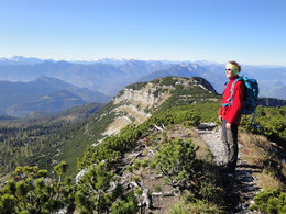
The rugged mountain range of the Hohe Schrott borders the Tote Gebirge to the west. The corner points of this massif, the Petergupf and the Hochglegt, are not difficult to reach - however, the complete crossing requires not only good physical condition, but also a cool view into the depths of the Trauntal. The long walk over the rocky footbridge also gives away a magnificent view of the Hohe Dachstein. From the railway station we do not go to the level crossing, but in the opposite direction alongside the tracks to the next junction. Turn left there, cross the bridge over the main road and follow the straight forest path to Offensee-Straße. Follow this into the valley to the second junction, then turn right to the Offensee power station and cross the Frauenweißenbach stream after the 210 marker. Turn left (into the valley) and shortly afterwards right uphill. After two hairpin bends, turn left; soon afterwards the marked mountain path to Brombergal (fountain) begins on the right. Over the mountain pine slope to the Petergupf and over the ridge to the Bannkogel (also Bahnkogel). Continue into the saddle in front of the rugged Bergwerkkogel, to the right on exposed rock ledges under an overhang ("Nagern") and to the left over vertical but well-stepped and secured wall steps to the summit. On or next to the airy ridge into the saddle in front of the Mittagkogel. Descend to the left and follow a wide grassy ledge across the rock face until you reach the southern slope of the mountain via a small chimney on the right. Cross this again to the ridge and - past the Schrottloch - to the summit cross of the Hohe Schrott. Descend further over the ridge into a depression and right onto the Hochglegt. At the edge of the broad summit slope, descend through mountain pine lanes and between weather trees to the Kotalm. The descent follows through steep forests and slopes. Cross three forest roads and descend through the Möselwiese to the Rettenbach district of Bad Ischl. Cross the stream and take the Steinfeldstraße back to Bad Ischl.
Most economical season
- Spring
- Summer
- Autumn
Please get in touch for more information.
4802 Ebensee
Phone +43 6133 8016
E-Mail ebensee@traunsee.at
Web www.traunsee.at/ebensee
http://www.traunsee.at/ebensee
Interactive elevation profile
Create PDF
Tour-Details
Starting place: 4802 Ebensee
Destination: 4802 Ebensee
duration: 9h 27m
length: 18,4 km
Altitude difference (uphill): 1.594m
Altitude difference (downhill): 1.562m
Lowest point: 438m
Highest point: 1.781m
difficulty: difficult
condition: difficult
panoramic view: Great panorama
Paths covering:
Hiking trail
powered by TOURDATA