© Photo: Oberösterreich Tourismus GmbH./Robert Maybach: Enjoy the view in Upper Austria


Erlakogel - die Nase der "Schlafenden Griechin"


Interactive elevation profile
Create PDF
Tour-Details
Path number: 421
Starting place: 4802 Ebensee
Destination: 4802 Ebensee
duration: 4h 53m
length: 6,1 km
Altitude difference (uphill): 1.170m
Altitude difference (downhill): 217m
Lowest point: 424m
Highest point: 1.522m
difficulty: medium
condition: medium
panoramic view: Great panorama
Paths covering:
Hiking trail
powered by TOURDATA
Challenging mountain hike to a striking rocky peak that requires a head for heights and surefootedness at the very top.
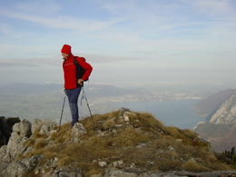
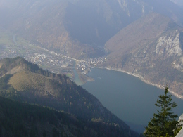
The striking profile of the Erlakogel - the "Sleeping Greek" - dominates the southern part of Lake Traunsee. Beneath the summit cross, you can enjoy a far-reaching view, marvellously above the Traunsee and very close to the Traunstein. There is also a "panorama visor", the top of which points to the surrounding mountain peaks.You can either start at the car park at the Rindbach leisure centre (chargeable, best to buy a day ticket), at the hiking car park near the shooting range or perhaps start at the town hall in Ebensee (Ebensee landing stage train stop), which is a 30-minute walk away.
From the leisure centre, walk upstream on the right-hand side of the stream, following the single-lane municipal road until you reach a bridge over the Rindbach on the left, where a separate signpost has been erected.
There begins path no. 421, the so-called "Loiperngrubn", which first leads to a transmission mast and then up to a sloping rock face (memorial plaque). Continue through the forest slope to a transverse forest road (spring). Above this is the Spitzelsteinalm, a private agricultural pasture, where you can take a short break on the bench (please be sure to take your rubbish back with you).
From the upper meadow saddle, the signposted trail heads to the right, shortening the bends in the forest road and winding its way up to a rocky forest ridge. Simply continue along the marked path, which was completely thinned out by storms Kyrill and Emma, but always offers a good view and quickly becomes snow-free in spring due to the open location. Finally, you scramble left over somewhat exposed but easily passable rocky ledges to the unconventionally designed summit cross. Here you have a wonderful view of Lake Traunsee and its surroundings. The descent follows the ascent route.
Walking time: around 3 hours for the ascent (from Rindbach), around 2 1/2 hours for the descent.
Refreshment stops:
None during the hike, inns in Ebensee or kiosk (April-October) at the leisure centre.
Note: If hikers park their vehicle at the Rindbach leisure centre, please note that the car park is subject to a charge and parking tickets should be clearly visible on the dashboard.
Most economical season
- Spring
- Summer
- Autumn
Please get in touch for more information.
Hauptstraße 34
4802 Ebensee
Phone +43 6133 8016
Fax machine +43 6133 8016870
E-Mail ebensee@traunsee-almtal.at
Web www.traunsee-almtal.at/ebensee
Web www.ebensee.at
http://www.traunsee-almtal.at/ebensee
http://www.ebensee.at
http://www.ebensee.at
Interactive elevation profile
Create PDF
Tour-Details
Path number: 421
Starting place: 4802 Ebensee
Destination: 4802 Ebensee
duration: 4h 53m
length: 6,1 km
Altitude difference (uphill): 1.170m
Altitude difference (downhill): 217m
Lowest point: 424m
Highest point: 1.522m
difficulty: medium
condition: medium
panoramic view: Great panorama
Paths covering:
Hiking trail
powered by TOURDATA