© Photo: Oberösterreich Tourismus GmbH./Robert Maybach: Enjoy the view in Upper Austria


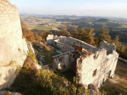
Ruine Klingenberg S8


Interactive elevation profile
Create PDF
Tour-Details
Starting place: 4364 St. Thomas am Blasenstein
Destination: 4364 St. Thomas am Blasenstein
duration: 3h 15m
length: 9,7 km
Altitude difference (uphill): 410m
Altitude difference (downhill): 409m
Lowest point: 565m
Highest point: 709m
difficulty: easy
condition: easy
panoramic view: Some Views
Paths covering:
Street, Hiking trail
powered by TOURDATA
Qualified hiking trail - the forecourt of the Klingenberg ruins with outstanding views is accessible, the ruins themselves are only accessible by appointment
Starting point: Starting point in front of the market town hall
Destination: Starting point in front of the market town hall
Accessibility / arrival
by car:
Highway exit Ybbs, Amstetten or Enns
Ybbs - Grein - St. Thomas am Bl.
Amstetten - Grein - St. Thomas am Bl.
Linz - Mauthausen - Perg - Münzbach - St Thomas am Bl.
by train:
By train to Perg and Grein and then approx. 14 km by post bus to St. Thomas am Bl.
Most economical season
- Spring
- Summer
- Autumn
Please get in touch for more information.
other information
- Toilet facility for disabled people
4364 St. Thomas am Blasenstein
Phone +43 7265 5455
E-Mail marktgemeinde@st-thomas.at
Web www.st-thomas.at
http://www.st-thomas.at
Interactive elevation profile
Create PDF
Tour-Details
Starting place: 4364 St. Thomas am Blasenstein
Destination: 4364 St. Thomas am Blasenstein
duration: 3h 15m
length: 9,7 km
Altitude difference (uphill): 410m
Altitude difference (downhill): 409m
Lowest point: 565m
Highest point: 709m
difficulty: easy
condition: easy
panoramic view: Some Views
Paths covering:
Street, Hiking trail
powered by TOURDATA