© Photo: Oberösterreich Tourismus GmbH./Robert Maybach: Enjoy the view in Upper Austria


Bleckwand


Interactive elevation profile
Create PDF
Tour-Details
Path number: 876/34
Starting place: 5350 Strobl
Destination: 5350 Strobl
duration: 3h 0m
length: 4,7 km
Altitude difference (uphill): 948m
Altitude difference (downhill): 10m
Lowest point: 563m
Highest point: 1.502m
difficulty: medium
condition: medium
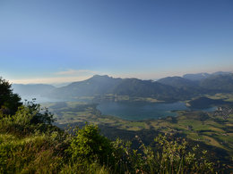
panoramic view: Great panorama
Paths covering:
Hiking trail
powered by TOURDATA
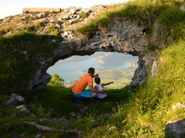
A mountain tour, ideal for walkers wanting a rewarding summit experience.
Start: Parking at the bus stop Gschwendt Landauer on the B158.Follow the signs Bleckwand No. 876/34 to the summit (1541 m).
Alternative: Start at Niedergadenalm (toll road).
Refreshment stops: Bleckwandhütte, Illighütte, Schwarzeneckhütte.
Accessibility / arrival
On the mainroad (B158) exit at the bobsleigh track and park there.
- Parking space: 10
- Suitable for kids (10 - 14 Year)
- Spring
- Summer
- Autumn
Please get in touch for more information.
Au 140
5350 Strobl
Phone +43 6138 8003
E-Mail info@wolfgangsee.at
Web www.wolfgangsee.at
http://www.wolfgangsee.at
Interactive elevation profile
Create PDF
Tour-Details
Path number: 876/34
Starting place: 5350 Strobl
Destination: 5350 Strobl
duration: 3h 0m
length: 4,7 km
Altitude difference (uphill): 948m
Altitude difference (downhill): 10m
Lowest point: 563m
Highest point: 1.502m
difficulty: medium
condition: medium
panoramic view: Great panorama
Paths covering:
Hiking trail
powered by TOURDATA