© Photo: Oberösterreich Tourismus GmbH./Robert Maybach: Enjoy the view in Upper Austria


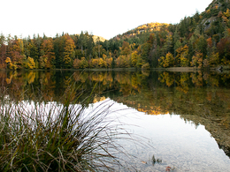
Lake Eibensee


- Flatly
Interactive elevation profile
Create PDF
Tour-Details
Starting place: 5340 St. Gilgen
Destination: 5340 St. Gilgen
duration: 3h 33m
length: 8,2 km
Altitude difference (uphill): 562m
Altitude difference (downhill): 561m
Lowest point: 567m
Highest point: 999m
difficulty: medium
condition: medium
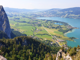
panoramic view: Great panorama
Paths covering:
Hiking trail
powered by TOURDATA
Hike to the hidden Eibensee and on to the summit of the Almkogel with a fantastic view of the entire Mondseeland.
Salzburgerstraße road - trail No. 13 towards Pöllingerstraße road - cross the main road - hamlet of Reith - Eibensee. Now either continue to the village of Fuschl (trail No. 13) and return by public bus, or walk down to the "Kleinerkapelle" wayside shrine (trail No. 13) to Mühlbachsau - Reit and back to the starting point.
Starting point: Mozart square St. Gilgen
Destination: Mozart square St. Gilgen
further information:
- Flatly
Accessibility / arrival Parking
The tour starts between Fuschl and St. Gilgen at the Kleiner Kapelle near the Gasthof Gimsenwirt.
- Parking space: 10
none
- Suitable for groups
- Suitable for friends
- Suitable for couples
- Spring
- Summer
- Autumn
Please get in touch for more information.
5360 St. Wolfgang im Salzkammergut
Phone +43 6138 8003
E-Mail info@wolfgangsee.at
Web www.wolfgangsee.at
http://www.wolfgangsee.at
Interactive elevation profile
Create PDF
Tour-Details
Starting place: 5340 St. Gilgen
Destination: 5340 St. Gilgen
duration: 3h 33m
length: 8,2 km
Altitude difference (uphill): 562m
Altitude difference (downhill): 561m
Lowest point: 567m
Highest point: 999m
difficulty: medium
condition: medium
panoramic view: Great panorama
Paths covering:
Hiking trail
powered by TOURDATA