© Photo: Oberösterreich Tourismus GmbH./Robert Maybach: Enjoy the view in Upper Austria


Niederhamer Weg


Interactive elevation profile
Create PDF
Tour-Details
Starting place: 4760 Raab
Destination: 4760 Raab
duration: 1h 42m
length: 6,3 km
Altitude difference (uphill): 87m
Altitude difference (downhill): 87m
Lowest point: 361m
Highest point: 426m
difficulty: very easy
condition: very easy
panoramic view: Individual Views
Paths covering:
Asphalt, Hiking trail
powered by TOURDATA
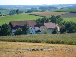
Route course:
Raab (school) - Niederham - Raab
Description:
The route leads from the school centre west towards Moarhof, then follows the riverside path along the Bründlbach stream and the Raaber Bach stream, which was regulated in the 1970s, to Niederham. On the way via Rackersedter Holz and Pfarrerholz, you can make a detour to Pfarrmaierhof once you have returned to Moarhof. Along the Bründlbach stream and then towards Markt, the trail leads back to the starting point.
Most economical season
- Spring
- Summer
- Autumn
- Early winter
- Deep winter
Please get in touch for more information.
Marktstraße 7
4760 Raab
Phone +43 7762 2255
E-Mail gemeinde@raab.ooe.gv.at
Web www.raab.ooe.gv.at/system/web/sonde…
http://www.raab.ooe.gv.at/system/web/sonderseite.aspx?menuonr=219567021&detailonr=219567021
Interactive elevation profile
Create PDF
Tour-Details
Starting place: 4760 Raab
Destination: 4760 Raab
duration: 1h 42m
length: 6,3 km
Altitude difference (uphill): 87m
Altitude difference (downhill): 87m
Lowest point: 361m
Highest point: 426m
difficulty: very easy
condition: very easy
panoramic view: Individual Views
Paths covering:
Asphalt, Hiking trail
powered by TOURDATA