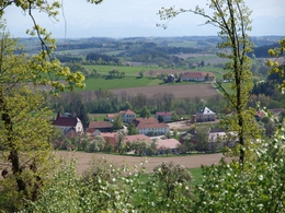
© Photo: Oberösterreich Tourismus GmbH./Robert Maybach: Enjoy the view in Upper Austria


Pollhamer Marterlroas


Interactive elevation profile
Create PDF
Tour-Details
Starting place: 4710 Pollham
Destination: 4710 Pollham
duration: 2h 45m
length: 10,1 km
Altitude difference (uphill): 155m
Altitude difference (downhill): 160m
Lowest point: 356m
Highest point: 473m
difficulty: easy
condition: easy
panoramic view: Individual Views
Paths covering:
Hiking trail
powered by TOURDATA
The "Pollhamer Marterlroas" is a beautiful hiking trail for the whole family to visit shrines, chapels and crosses in the municipality of Pollham.
The entire route can be hiked in around three hours.
Folders are available at the municipal office.
The entire route can be hiked in around three hours.
Folders are available at the municipal office.
Most economical season
- Spring
- Summer
- Autumn
Please get in touch for more information.
Pollham
4710 Pollham
Phone +43 7248 68712
Fax machine +43 7248 68712 - 20
E-Mail gemeinde@pollham.ooe.gv.at
Web www.pollham.at
http://www.pollham.at
Interactive elevation profile
Create PDF
Tour-Details
Starting place: 4710 Pollham
Destination: 4710 Pollham
duration: 2h 45m
length: 10,1 km
Altitude difference (uphill): 155m
Altitude difference (downhill): 160m
Lowest point: 356m
Highest point: 473m
difficulty: easy
condition: easy
panoramic view: Individual Views
Paths covering:
Hiking trail
powered by TOURDATA