© Photo: Oberösterreich Tourismus GmbH./Robert Maybach: Enjoy the view in Upper Austria


Marterl- und Kapellenweg
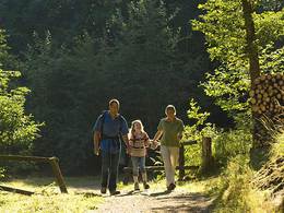


- Suitable for families
- Suitable for kids (all ages)
- Flatly
Interactive elevation profile
Create PDF
Tour-Details
Starting place: 4775 Taufkirchen an der Pram
Destination: 4775 Taufkirchen an der Pram
duration: 3h 10m
length: 11,9 km
Altitude difference (uphill): 153m
Altitude difference (downhill): 161m
Lowest point: 324m
Highest point: 421m
difficulty: very easy
condition: very easy
panoramic view: Some Views
Paths covering:
Asphalt, Gravel
powered by TOURDATA
Route:
Taufkirchen an der Pram - Berndobler Straße - Baumgarten - Höbmannsbach - Feicht - Hubertuskapelle - Schwendt - Wagholming - Windten - Furth - Kinosiedlung - Taufkirchen an der Pram
Description:
The Marterl and Chapel Trail is 12 kilometres long and starts at the town square in Taufkirchen an der Pram. The trail leads via Berndobler Straße to the "Nöchlbauer" and Rochuskapelle, past the "Schernbauer", to the chapel in Baumgarten, on to the Bründlkapelle, to Höbmannsbach and past the village chapel. In Feicht you can visit the Siebenschläfer wayside shrine, continue to the Hubertus Chapel, to Schwendt, to the filial church in Wagholming. The route continues via Windten and Fürth. After a visit to the radio museum in the cinema settlement, you return to Taufkirchen an der Pram on the B 129.
further information:
- Flatly
Details - hiking
- themed path
- Suitable for groups
- Suitable for kids (all ages)
- Suitable for teenagers
- Suitable for single travelers
- Suitable for families
- Suitable for couples
- Suitable for children
- Spring
- Summer
- Autumn
Please get in touch for more information.
Schärdinger Straße 1
4775 Taufkirchen an der Pram
Phone +43 7719 7255
Fax machine +43 7719 7255 - 30
E-Mail gemeinde@taufkirchen-pram.ooe.gv.ag
Web www.taufkirchen-pram.at
http://www.taufkirchen-pram.at
Interactive elevation profile
Create PDF
Tour-Details
Starting place: 4775 Taufkirchen an der Pram
Destination: 4775 Taufkirchen an der Pram
duration: 3h 10m
length: 11,9 km
Altitude difference (uphill): 153m
Altitude difference (downhill): 161m
Lowest point: 324m
Highest point: 421m
difficulty: very easy
condition: very easy
panoramic view: Some Views
Paths covering:
Asphalt, Gravel
powered by TOURDATA