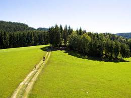
© Photo: Oberösterreich Tourismus GmbH./Robert Maybach: Enjoy the view in Upper Austria


Kirchensteig Laufenbach - Maad


Interactive elevation profile
Create PDF
Tour-Details
Starting place: 4775 Taufkirchen an der Pram
Destination: 4775 Taufkirchen an der Pram
duration: 1h 10m
length: 4,6 km
Altitude difference (uphill): 48m
Altitude difference (downhill): 19m
Lowest point: 324m
Highest point: 378m
difficulty: easy
condition: easy
panoramic view: Individual Views
Paths covering:
Asphalt, Gravel
powered by TOURDATA
Route:
Taufkirchen an der Pram - Bachschwölln - Gmeinau - Laufenbach - Maad -Taufkirchen an der Pram
Description:
The Laufbach - Maad church trail is 10 kilometres long and starts at the town square in Taufkirchen an der Pram. The trail leads via Bachschwölln and Gmeinau to Laufenbach, where there is a village chapel and the famous crafts museum. Passing the golf course in Maad, you return to Taufkirchen an der Pram.
Most economical season
- Spring
- Summer
- Autumn
Please get in touch for more information.
Schärdinger Straße 1
4775 Taufkirchen an der Pram
Phone +43 7719 7255
Fax machine +43 7719 7255 - 30
E-Mail gemeinde@taufkirchen-pram.ooe.gv.at
Web www.taufkirchen-pram.at
http://www.taufkirchen-pram.at
Interactive elevation profile
Create PDF
Tour-Details
Starting place: 4775 Taufkirchen an der Pram
Destination: 4775 Taufkirchen an der Pram
duration: 1h 10m
length: 4,6 km
Altitude difference (uphill): 48m
Altitude difference (downhill): 19m
Lowest point: 324m
Highest point: 378m
difficulty: easy
condition: easy
panoramic view: Individual Views
Paths covering:
Asphalt, Gravel
powered by TOURDATA