© Photo: Oberösterreich Tourismus GmbH./Robert Maybach: Enjoy the view in Upper Austria
Enjoy the view in Upper Austria
search
Search
Close

Parzertal Nr. 136

 Interactive elevation profile

Download GPS data
Create PDF

Tour-Details

Starting place: 5222 Munderfing
Destination: 5222 Munderfing

duration: 1h 45m
length: 5,6 km
Altitude difference (uphill): 203m
Altitude difference (downhill): 125m

Lowest point: 503m
Highest point: 698m
difficulty: easy
condition: very easy
panoramic view: Individual Views

Paths covering:
Street, Hiking trail, Other

powered by TOURDATA

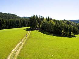
The starting point is the Gasthau Pfandlwirt (Rosenhammer-Stegmüller family) in Munderfing, Parz no. 7, in the direction of Parzertal trail no. 136 towards Weißenstein (approx. 2.5 km) - Altes Katztal, approx. 5 km in total.
Travelling by public transport
Route planner for independent travellers
Most economical season
  • Spring
  • Summer
  • Autumn

Please get in touch for more information.


Parzertal Nr. 136
Gemeinde Munderfing
Dorfplatz 1
5222 Munderfing

Phone +43 7744 6255
E-Mail gemeinde@munderfing.ooe.gv.at
Web www.munderfing.at
http://www.munderfing.at

We speak the following languages

German

 Interactive elevation profile

Download GPS data
Create PDF

Tour-Details

Starting place: 5222 Munderfing
Destination: 5222 Munderfing

duration: 1h 45m
length: 5,6 km
Altitude difference (uphill): 203m
Altitude difference (downhill): 125m

Lowest point: 503m
Highest point: 698m
difficulty: easy
condition: very easy
panoramic view: Individual Views

Paths covering:
Street, Hiking trail, Other

powered by TOURDATA