© Photo: Oberösterreich Tourismus GmbH./Robert Maybach: Enjoy the view in Upper Austria


Urtl-Weg 5,5 km


Interactive elevation profile
Create PDF
Tour-Details
Starting place: 4722 Peuerbach
Destination: 4722 Peuerbach
duration: 1h 34m
length: 5,6 km
Altitude difference (uphill): 102m
Altitude difference (downhill): 100m
Lowest point: 393m
Highest point: 482m
difficulty: easy
condition: easy
panoramic view: Some Views
Paths covering:
Asphalt, Gravel, Hiking trail
powered by TOURDATA
The Urtlweg trail follows in the footsteps of the legend of the Peuerbach Urtl springs to the three publicly accessible pools in the high country around Peuerbach.
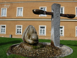
Starting point and destination: Peuerbach Castle. From the castle, cross the main road and walk across the church square to the parish church. Turn right in front of the church, walk around the old primary school and come to the sculpture "Der Gebückte", where you can read the legend.
Follow Christoph-Zeller-Straße to the left for a short distance, then take the path to the right and pass the Turner monument. You walk along the forest (possibility to use the Leithentalweg or Römerweg) and finally reach the village of Kastlingeredt. Follow the Kastlingeredt municipal road for approx. 170 metres to the right and turn left towards Spielmannsberg. Here, on the left-hand side, the "Jausen-Stubn" snack bar invites you to take a break. (Option to follow the Alm-Mühlen-Runde via the Schneiderbauerhöhenweg). Follow the path to the left, keep left again at the fork in Besenberg and you will reach Georg-von-Peuerbach-Straße. Opposite the Panhölzl bakery is the "Bäcker-Urtl", where the fresh Urtl water first comes out of the ground. Continue along the road and then turn sharp left opposite the Sparkasse bank into the ditch. Here you will find the "Kneipp-Urtl" at the small "Roßanger" park. This facility invites hikers to take a break and enjoy a Kneipp treatment. Cross the small bridge over the Ledererbach stream to reach the church and return to Peuerbach Castle via the church square.
Most economical season
- Spring
- Summer
- Autumn
Please get in touch for more information.
4722 Peuerbach
Phone +43 7276 2255 - 203
E-Mail stadt@peuerbach.ooe.gv.at
Web www.peuerbach.at
https://www.peuerbach.at
Interactive elevation profile
Create PDF
Tour-Details
Starting place: 4722 Peuerbach
Destination: 4722 Peuerbach
duration: 1h 34m
length: 5,6 km
Altitude difference (uphill): 102m
Altitude difference (downhill): 100m
Lowest point: 393m
Highest point: 482m
difficulty: easy
condition: easy
panoramic view: Some Views
Paths covering:
Asphalt, Gravel, Hiking trail
powered by TOURDATA