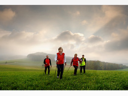
© Photo: Oberösterreich Tourismus GmbH./Robert Maybach: Enjoy the view in Upper Austria


Lauf & Walking Park Schneegattern Runde S1


Interactive elevation profile
Create PDF
Tour-Details
Starting place: 5211 Lengau
Destination: 5211 Lengau
duration: 2h 39m
length: 9,8 km
Altitude difference (uphill): 139m
Altitude difference (downhill): 140m
Lowest point: 532m
Highest point: 639m
difficulty: medium
condition: medium
panoramic view: Individual Views
Paths covering:
Asphalt, Gravel
powered by TOURDATA
Choose from 3 different Nordic walking and running routes and there are also connecting routes to the Running & Walking Park Friedburg - Lengau with 8 routes, approx. 64 km. The connecting routes V1 & V2 link the Friedburg - Schneegattern - Naturfreundehaus route boards. These routes are marked but not signposted.
S1 UNIQUA RUNDE "Krenwald" - difficultMarking: redLength: 10.40 kmTotal ascent: 85 mTo revitalise yourself and take a deep breath, the red Uniqua round is the perfect route. Starts at the village square and leads slightly uphill through the Krenwald forest. You cycle on firm gravel and natural surfaces in the peaceful countryside. You return to the start via Utzweih.
S1 UNIQUA RUNDE "Krenwald" - difficultMarking: redLength: 10.40 kmTotal ascent: 85 mTo revitalise yourself and take a deep breath, the red Uniqua round is the perfect route. Starts at the village square and leads slightly uphill through the Krenwald forest. You cycle on firm gravel and natural surfaces in the peaceful countryside. You return to the start via Utzweih.
Most economical season
- Spring
- Summer
- Autumn
- Early winter
Please get in touch for more information.
Salzburger Strasse 9
5211 Lengau
Phone +43 7746 2202 - 0
E-Mail gemeinde@lengau.ooe.gv.at
Web www.gemeindelengau.at
http://www.gemeindelengau.at
Interactive elevation profile
Create PDF
Tour-Details
Starting place: 5211 Lengau
Destination: 5211 Lengau
duration: 2h 39m
length: 9,8 km
Altitude difference (uphill): 139m
Altitude difference (downhill): 140m
Lowest point: 532m
Highest point: 639m
difficulty: medium
condition: medium
panoramic view: Individual Views
Paths covering:
Asphalt, Gravel
powered by TOURDATA