© Photo: Oberösterreich Tourismus GmbH./Robert Maybach: Enjoy the view in Upper Austria


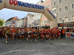
Rieder Stadtlauf


- All weather
- Suitable for families
- Suitable for pushchairs
- Suitable for kids (all ages)
- Flatly
Interactive elevation profile
Create PDF
Tour-Details
Starting place: 4910 Ried im Innkreis
Destination: 4910 Ried im Innkreis
duration: 0h 24m
length: 2,5 km
Altitude difference (uphill): 9m
Altitude difference (downhill): 10m
Lowest point: 428m
Highest point: 439m
difficulty: very easy
condition: very easy
panoramic view: No view
Paths covering:
Asphalt
powered by TOURDATA
The famous Rieder city run starts at the main square in Ried im Innkreis and leads via Friedrich-Thurner-Road, Schärdinger road and Hartwagner road back to the starting point. The loop is only marked in the map.
- All weather
- Suitable for groups
- Suitable for schools
- Suitable for kids (all ages)
- Suitable for pushchairs
- Suitable for teenagers
- Suitable for seniors
- Suitable for single travelers
- Suitable for families
- Suitable for friends
- Suitable for couples
- Spring
- Summer
- Autumn
- Early winter
- Deep winter
Please get in touch for more information.
Hauptplatz
4910 Ried im Innkreis
Phone +43 7752 901
E-Mail office@ried.gv.at
Web www.rieder-stadtlauf.at
Web www.ried.at
https://www.rieder-stadtlauf.at
http://www.ried.at
http://www.ried.at
Interactive elevation profile
Create PDF
Tour-Details
Starting place: 4910 Ried im Innkreis
Destination: 4910 Ried im Innkreis
duration: 0h 24m
length: 2,5 km
Altitude difference (uphill): 9m
Altitude difference (downhill): 10m
Lowest point: 428m
Highest point: 439m
difficulty: very easy
condition: very easy
panoramic view: No view
Paths covering:
Asphalt
powered by TOURDATA