© Photo: Oberösterreich Tourismus GmbH./Robert Maybach: Enjoy the view in Upper Austria


Grünbergweg


- Flatly
Interactive elevation profile
Create PDF
Tour-Details
Starting place: 4283 Bad Zell
Destination: 4283 Bad Zell
duration: 0h 55m
length: 3,1 km
Altitude difference (uphill): 84m
Altitude difference (downhill): 80m
Lowest point: 506m
Highest point: 591m
difficulty: easy
condition: easy
panoramic view: Individual Views
Paths covering:
Asphalt, Hiking trail
powered by TOURDATA
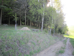
The path leads past the Hotel Lebensquell and the Kurhotel up Bad Zell's local mountain to the Grünberg with a beautiful view of the market.
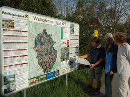
Starting point: directly at the Lebensquell health centre / primary school car park with information and overview board
further information:
- Flatly
Information at...
Tourism Association Bad Zell
or at
Health Resort Lebensquell - 07263 7515
Accessibility / arrival
by car:
Vienna: A1 exit Enns-Mauthausen-Perg (14km)-Bad Zell
Linz: A7-Unterweitersdorf-Pregarten-Tragwein-Bad Zell
by train:
Vienna: Linz (train) from Linz with the Postbus to Bad Zell - 40 km; or to Pregarten by train - 20 km to Bad Zell
Most economical season
- Spring
- Summer
- Autumn
Please get in touch for more information.
Lebensquellplatz 1
4283 Bad Zell
Phone +43 5 07263 - 0
E-Mail badzell@muehlviertel.at
Web www.kulturforum-badzell.at
https://www.kulturforum-badzell.at
Interactive elevation profile
Create PDF
Tour-Details
Starting place: 4283 Bad Zell
Destination: 4283 Bad Zell
duration: 0h 55m
length: 3,1 km
Altitude difference (uphill): 84m
Altitude difference (downhill): 80m
Lowest point: 506m
Highest point: 591m
difficulty: easy
condition: easy
panoramic view: Individual Views
Paths covering:
Asphalt, Hiking trail
powered by TOURDATA