© Photo: Oberösterreich Tourismus GmbH./Robert Maybach: Enjoy the view in Upper Austria


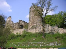
Burgruine Prandegg


- culturally interesting
- Flatly
Interactive elevation profile
Create PDF
Tour-Details
Starting place: 4283 Bad Zell
Destination: 4283 Bad Zell
duration: 6h 30m
length: 23,0 km
difficulty: medium
condition: medium
panoramic view: Great panorama
Paths covering:
Asphalt, Hiking trail
powered by TOURDATA
On forest and meadow paths through the beautiful Mühlviertel hills to the second largest castle complex in Upper Austria, the Prandegg ruins - Taverne zu Prandegg.
Beautiful panoramic view from the observation tower into the Waldaist valley.
Return via the village of Hirtlhof to Bad Zell.
Taverne zu Prandegg, Franz Leitner, 0664/5736973
1.5. to 31.10.: daily from 8 am - 1.11. to 30.4.: Sat./Sun. from 11 am
Beautiful panoramic view from the observation tower into the Waldaist valley.
Return via the village of Hirtlhof to Bad Zell.
Taverne zu Prandegg, Franz Leitner, 0664/5736973
1.5. to 31.10.: daily from 8 am - 1.11. to 30.4.: Sat./Sun. from 11 am
Starting point: directly at the Lebensquell health centre / primary school car park
further information:
- Flatly
- Board possible
Information at the tourist office or at the Lebensquell health resort
Accessibility / arrival
by car:
Vienna: A1 exit Enns-Mauthausen-Perg (14km)-Bad Zell
Linz: A7-Unterweitersdorf-Pregarten-Tragwein-Bad Zell
by train:
Vienna: Linz (train) from Linz with the Postbus to Bad Zell - 40 km; or to Pregarten by train - 20 km to Bad Zell
Most economical season
- Spring
- Summer
- Autumn
Please get in touch for more information.
Lebensquellplatz 1
4283 Bad Zell
Phone +43 5 07263 - 0
E-Mail badzell@muehlviertel.at
Web www.kulturforum-badzell.at
Web www.prandegg.com/
https://www.kulturforum-badzell.at
http://www.prandegg.com/
http://www.prandegg.com/
Interactive elevation profile
Create PDF
Tour-Details
Starting place: 4283 Bad Zell
Destination: 4283 Bad Zell
duration: 6h 30m
length: 23,0 km
difficulty: medium
condition: medium
panoramic view: Great panorama
Paths covering:
Asphalt, Hiking trail
powered by TOURDATA