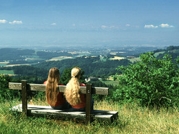
© Photo: Oberösterreich Tourismus GmbH./Robert Maybach: Enjoy the view in Upper Austria


Karl Waldeck-Wanderweg S3


- pets allowed
- All weather
- Suitable for families
- Suitable for kids (all ages)
- culturally interesting
- Flatly
Interactive elevation profile
Create PDF
Tour-Details
Path number: S3
Starting place: 4364 St. Thomas am Blasenstein
Destination: 4364 St. Thomas am Blasenstein
duration: 0h 58m
length: 3,0 km
Altitude difference (uphill): 115m
Altitude difference (downhill): 115m
Lowest point: 605m
Highest point: 704m
difficulty: easy
condition: easy
panoramic view: Dreamtour
Paths covering:
Asphalt, unfixed
powered by TOURDATA
Extension of the procession route to be even closer to the Alps for longer.
The hike begins in front of the market town hall.This path is dedicated to the St. Thomingen composer and Bruckner's successor Karl Waldeck.
A composition of forest, meadows and panoramic views in the sunshine.
Starting point: Market town hall
Destination: Market town hall
further information:
- Flatly
Always accessible, but no snow clearance in winter.
Accessibility / arrival
By car and bus to the starting point in the town center.
Parking- Parking space: 50
- Bus parking space: 1
none
Shuttle servicenone
General price information
Mühlviertel Nature Park hiking map (municipalities: Allerheiligen, Bad Zell, St. Thomas, Rechberg) available for € 2.00 at the market town office, inn Ahorner, Doll's House Museum and at Nah & Frisch.
- All weather
- Suitable for groups
- Suitable for schools
- Suitable for kids (all ages)
- Pets allowed
- Suitable for families
- Suitable for friends
- Suitable for couples
- Suitable for children
- Spring
- Summer
- Autumn
Please get in touch for more information.
Markt 7
4364 St. Thomas am Blasenstein
Phone +43 7265 5455
E-Mail marktgemeinde@st-thomas.at
Web www.st-thomas.at
http://www.st-thomas.at
Interactive elevation profile
Create PDF
Tour-Details
Path number: S3
Starting place: 4364 St. Thomas am Blasenstein
Destination: 4364 St. Thomas am Blasenstein
duration: 0h 58m
length: 3,0 km
Altitude difference (uphill): 115m
Altitude difference (downhill): 115m
Lowest point: 605m
Highest point: 704m
difficulty: easy
condition: easy
panoramic view: Dreamtour
Paths covering:
Asphalt, unfixed
powered by TOURDATA