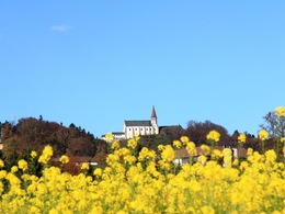
© Photo: Oberösterreich Tourismus GmbH./Robert Maybach: Enjoy the view in Upper Austria


Felder, Bäche und Romantik S9


- Flatly
Interactive elevation profile
Create PDF
Tour-Details
Path number: S9
Starting place: 4364 St. Thomas am Blasenstein
Destination: 4364 St. Thomas am Blasenstein
duration: 5h 28m
length: 17,2 km
Altitude difference (uphill): 612m
Altitude difference (downhill): 608m
Lowest point: 359m
Highest point: 709m
difficulty: medium
condition: medium
panoramic view: Some Views
Paths covering:
Asphalt, Gravel, unfixed, Hiking trail
powered by TOURDATA
Viewpoints and, above all, a wild and romantic valley make up for the section on tarmac.
Up to the chapel on the S4. Then turn right along the main road, after the small forest turn left to the "Schwarzgruber" house. On the Grössing goods road to the Edmair chapel, left over the plateau past the "Hochstrasser" house, then right through the forest. Cross a footbridge over a stream to the Stilles Tal municipal road. Pass the Stilles Tal inn on the left (known for its fresh, delicious trout dishes), turn right before the Grill'n bridge and 50 metres later turn left into the beautiful, wild and romantic Senftmühlbach valley. Up through the forest to the district road. Turn right towards Pabneukirchen and then take the first access road on the left. Through meadows and forests to the "Waldpeter" house. Now take the S8 back to the village. Starting point: Starting point in front of the market town hall
Destination: Starting point in front of the market town hall
further information:
- Flatly
Accessibility / arrival
by car:
Highway exit Ybbs, Amstetten or Enns
Ybbs - Grein - St. Thomas am Bl.
Amstetten - Grein - St. Thomas am Bl.
Linz - Mauthausen - Perg - Münzbach - St Thomas am Bl.
by train:
By train to Perg and Grein and then approx. 14 km by post bus to St. Thomas am Bl.
Airport Linz/Hörsching or Salzburg
General price information
Hiking map of the Mühlviertel Nature Park (municipalities: Allerheiligen, Bad Zell, St. Thomas, Rechberg) available for € 2.00 at the market town office, inn Ahorner, Doll's House Museum and at Nah & Frisch.
Most economical season
- Spring
- Summer
- Autumn
Please get in touch for more information.
other information
- Toilet facility for disabled people
4364 St. Thomas am Blasenstein
Phone +43 7265 5455
E-Mail marktgemeinde@st-thomas.at
Web www.st-thomas.at
http://www.st-thomas.at
Interactive elevation profile
Create PDF
Tour-Details
Path number: S9
Starting place: 4364 St. Thomas am Blasenstein
Destination: 4364 St. Thomas am Blasenstein
duration: 5h 28m
length: 17,2 km
Altitude difference (uphill): 612m
Altitude difference (downhill): 608m
Lowest point: 359m
Highest point: 709m
difficulty: medium
condition: medium
panoramic view: Some Views
Paths covering:
Asphalt, Gravel, unfixed, Hiking trail
powered by TOURDATA