

Hallstatt - Echern Theme Trail to the waterfalls


- pets allowed
- Flatly
Interactive elevation profile
Create PDF
Tour-Details
Paths covering:
Austria's best known Romantics and artists all set up their easels in the Echerntal Valley. In the 1900s, this valley was known as "The Place for Romantics".
In the footsteps of the 19th century Romantics
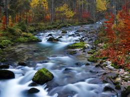
Along the themed trail, you will experience unspoilt nature, mountain streams, waterfalls, the glacier garden and information about the most important people of Romanticism who came to the Echerntal.
Starting from car park 2, next to the valley station of the Salzbergbahn cable car, the trail leads along the Waldbach stream through the picturesque settlement in the Echerntal valley, where old and traditional houses can be admired along the way.
On arrival at the pavilion, newly built by pupils of the HTBLA Hallstatt, the trail continues along the babbling brook accompanied by information boards of famous painters and writers, such as Adalbert Stifter and Ferdinand Georg Waldmüller. Even back then, artists appreciated the tranquillity and pure nature in the Echerntal as inspiration for their works.
Past the Simony monument, there is a turn-off to what is probably one of the most breathtaking natural monuments in our region - the glacier garden.
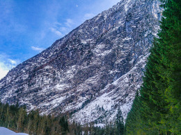
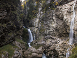
The glacier garden, a relic of the last ice age - from the glacier that retreated around 12,000 years ago - leaves every visitor amazed. Over time, the rock was ground out by the rock particles from the meltwater flowing from the glacier, forming glacial potholes. After a long period of rain, the glacial potholes are filled with water. After a 1.5-hour hike on flat terrain through the flora and fauna of the unspoilt forest area, you reach the end of the Echern Valley. Once there, you can already feel the spray from the thundering waterfalls, which plunge over 50 metres into the depths.
After a short climb, you reach one of the most beautiful places around the World Heritage town of Hallstatt. Take your time to enjoy the breathtaking panorama, try to forget the often stressful everyday life and take in the power and energy that is radiated from the cascading masses of water in this place.
Order hiking maps for the Dachstein Salzkammergut region ...
To the 360° panoramic tour through Hallstatt...
Mountain rescue: 140
further information:
- Flatly
Details - hiking
- themed path
The theme trail is open all season; in case of high snow or ice the trail could be closed.
The trail starts on parking number 2
By car:
* Salzburg - Highway A1 – Exit Thalgau – Bad Ischl – 20 km to Hallstatt
* Vienna - Highway A1 – Exit Regau – Bad Ischl – Hallstatt
* Villach - exit Golling or St. Martin - Richtung Gosau - Hallstatt
* Graz - Liezen - Bad Aussee - Obertraun - Hallstatt
By train: www.oebb.at and westbahn.at
* Vienna: Railway station Vienna West – Attnang Puchheim – Hallstatt – ferry
* Salzburg: Salzburg – Attnang Puchheim – Bad Ischl – Hallstatt – ferry
By bus from Salzburg:
*Salzburg – Bad Ischl – Hallstatt
www.postbus.at
From € 3,00 per hour
- Suitable for groups
- Suitable for schools
- Pets allowed
- Suitable for single travelers
- Spring
Please get in touch for more information.
")
Seestraße 114
4830 Hallstatt
Phone +43 5 95095 - 30
Fax machine +43 5 95095 - 74
E-Mail hallstatt@dachstein-salzkammergut.at
Web www.dachstein-salzkammergut.at
You can also visit us on
Visit us on Facebook Visit us on Instagram Visit us on Pinterest Visit our videochannel on YouTube WikipediaInteractive elevation profile
Create PDF
Tour-Details
Paths covering: