

Dachstein Cave Path


- Suitable for families
Interactive elevation profile
Create PDF
Tour-Details
Paths covering:
Wonderful cycle tour in Obertraun past the Koppenwinklsee lake, the valley station of the Dachstein Krippenstein cable car and back to the Obertraun Dachsteinhöhlen railway station.
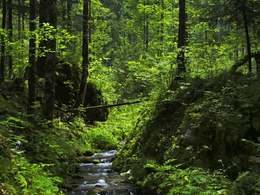
Bike tour for nature lovers
The trail takes you from the railway station Obertraun Koppenbrüllerhöhle, past the Lake Koppenwinkl over a forest road to the valley station of the Dachstein Krippenstein cable car.
Why not make a small excursion and visit the Dachstein Giant Ice Cave or/and the Mammoth Cave. Especially on hot summer days this excursion will bring you refreshment.
Continue by bike through the forest down to the former Dachsteinhof and over the Köhler Bridge, along the Höll-Karl-Weg and through the village of Obertraun to the railway station Obertraun Dachsteinhöhlen.
Along the Dachstein Cave Path you will pass idyllic places which invite you to take a break. This path takes you away from the hectic daily world into the tranquillity of nature in the World Heritage region Hallstatt-Dachstein/Salzkammergut.
The trail is also popular among school groups, travel groups and families. The entire Dachstein Cave Trail is clearly signposted!
Important details:
Difference in altitude 50 m
Proposed hiking route approx. 5 km
Travel time approx. 0.5 hours
In case of emergency call the mountain rescue under 140!
Experience a 360° panorama tour through Obertraun…
by car
from Salzburg:
Federal road B158 direction Bad Ischl
in Bad Ischl driveway onto Salzkammergut Straße B145 in direction to Bad Goisern, Hallstatt and Obertraun, in Obertraun direction railway station Obertraun Koppenbrüllerhöhle
from Linz:
A1 motorway exit Regau on Salzkammergut Straße B145 direction Gmunden, Bad Goisern, Hallstatt and Obertraun, in Obertraun direction railway station Obertraun Koppenbrüllerhöhle
from Graz:
A9 motorway exit Liezen on B320
in Trautenfels turn onto Salzkammergut Straße B145 via Bad Aussee to Obertraun
from Villach:
A10 Tauernautobahn to exit "Eben im Pongau", from there via Annaberg, Gosau and Hallstatt to Obertraun, in Obertraun direction railway station Obertraun Koppenbrüllerhöhle
by bus:
get off at the bus station “Obertraun Feriendorf” and then by bike about 10 minutes to the starting point
by train:
from Linz/Salzburg to Attnang-Puchheim, change to train to Stainach-Irdning
or from Stainach-Irdning Zug direction Attnang-Puchheim
get off at train station "Obertraun Koppenbrüllerhöhle"
Detailed information on the respective train and bus times can be found at https://www.oebb.at/en/ (train) and https://www.postbus.at/en (bus).
- Parking space: 5
free of charge
- Suitable for groups
- Suitable for schools
- Suitable for teenagers
- Suitable for seniors
- Suitable for single travelers
- Suitable for families
- Suitable for friends
- Suitable for couples
- Suitable for children
- Spring
- Summer
- Autumn
Please get in touch for more information.
Kirchengasse 4
4831 Obertraun
Phone +43 5 95095 - 40
E-Mail info@dachstein-salzkammergut.at
Web www.dachstein-salzkammergut.at
You can also visit us on
Visit us on Facebook Visit us on Instagram Visit us on Pinterest Visit our videochannel on YouTube WikipediaInteractive elevation profile
Create PDF
Tour-Details
Paths covering: