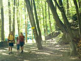
© Photo: Oberösterreich Tourismus GmbH./Robert Maybach: Enjoy the view in Upper Austria


G4 Panoramaweg - Mitterbach


- pets allowed
- All weather
- Flatly
- Possible accommodation
Interactive elevation profile
Create PDF
Tour-Details
Path number: G 4
Starting place: 4264 Grünbach
Destination: 4264 Grünbach
duration: 2h 31m
length: 8,3 km
Altitude difference (uphill): 237m
Altitude difference (downhill): 244m
Lowest point: 826m
Highest point: 951m
difficulty: medium
condition: medium
panoramic view: Individual Views
Paths covering:
Hiking trail
powered by TOURDATA
Beautiful circular route from Gasthof Kastler to Hussenstein and back again via St. Michael.
The starting point for this hike across the beautiful Mühlviertel high plateau is the Forellenwirt inn in Mitterbach. From the Forellenwirt you walk past the fish ponds through a wooded area.After this wooded area, the route continues for a short distance along the B 38, which you cross. Now follow the "Güterweg Fünfling" for a while, then the hiking trail branches off to the right to the legendary "Felsen vom Hussenstein".
In addition to the "Hussenstein" itself, there are many other rocks and stones of this type, which have been shaped into their present form by the weathering of wool sacks.
From the "Hussenstein", follow the markings in the direction of Oberrauchenödt into a valley incision. There you cross a small stream and turn right onto the forest road. After a few hundred metres, follow a forest path to the B38.
After crossing the B38 a second time, you will be rewarded with a marvellous panoramic view. A short way uphill and you will see the late Gothic church of St Michael on the left, which is definitely worth a visit. We also recommend a visit to the viewing platform with the panorama board to the west of the church. After a final stage of approx. 25 minutes, you will return to the Forellenwirt Kastler.
Starting point: Gasthof Forellenwirt, Mitterbach 6
Destination: Gasthof Forellenwirt, Mitterbach 6
further information:
- Flatly
- Possible accommodation
- Board possible
Accessibility / arrival
by car:
from Linz - A7 - Mühlviertler Straße - B38 Egelsee - Mitterbach - Panoramaweg starts at Gasthof Kastler
- All weather
- Suitable for groups
- Suitable for schools
- Suitable for kids (6 - 14 Year)
- Pets allowed
- Spring
- Summer
- Autumn
- Early winter
Please get in touch for more information.
")
Marktplatz 1
4264 Grünbach
Phone +43 7942 72813 - 0
E-Mail anfrage@muehlviertel.at
Web www.gruenbach.ooe.gv.at/
Web www.muehlviertel-urlaub.at/wandern
https://www.gruenbach.ooe.gv.at/
http://www.muehlviertel-urlaub.at/wandern
http://www.muehlviertel-urlaub.at/wandern
Interactive elevation profile
Create PDF
Tour-Details
Path number: G 4
Starting place: 4264 Grünbach
Destination: 4264 Grünbach
duration: 2h 31m
length: 8,3 km
Altitude difference (uphill): 237m
Altitude difference (downhill): 244m
Lowest point: 826m
Highest point: 951m
difficulty: medium
condition: medium
panoramic view: Individual Views
Paths covering:
Hiking trail
powered by TOURDATA