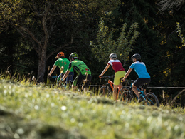
© Photo: Oberösterreich Tourismus GmbH./Robert Maybach: Enjoy the view in Upper Austria


Garstnertaler Höhenrunde MTB1


- Flatly
Interactive elevation profile
Create PDF
Tour-Details
Starting place: 4582 Spital am Pyhrn
Destination: 4582 Spital am Pyhrn
duration: 3h 0m
length: 29,5 km
Altitude difference (uphill): 900m
Altitude difference (downhill): 900m
Lowest point: 655m
Highest point: 1.286m
difficulty: medium
condition: medium
panoramic view: Some Views
Paths covering:
Asphalt, Gravel, unfixed
powered by TOURDATA
Spital am Pyhrn - Oberweng/Flinderlmühle - Pramfeldner Reith - Schwarzkogel - Innerrosenau - Rosenau - Zottensberg - Oberweng/Flinderlmühle - Spital am Pyhrn
Along the B 138 (marked cycle lane) towards Windischgarsten for 1 km - after the subway, turn right to the Oberweng goods road junction. Asphalted goods road ascending relatively evenly, flat in the upper part, to the Flinderlmühle, where the "Garstnertaler Höhenrunde" actually begins. The approach route is also part of the Oberweng Panorama Route.
The route now leads for 5.4 km on a well-built, evenly ascending forest road (gravel) branching off to the left from the Winklertalstraße up to the Pramfeldner Reith (1,130m) and on to the Schwarzkogel (1,296m), the highest point of this loop. Follow the road downhill for 5 kilometres, past a timber yard and the idyllic source of the Dambach. After 5 km, shortly after a forestry barrier, the tarmac road begins, which now runs for 6.2 km to the Schneckenstraße junction. First you pass the Innerrosenau biathlon centre and the Lambergerteich snack station. At the junction with Hengstpass Straße (4 km to Hengstpass 1,010m), turn left into the village of Rosenau, past the large timber yards of the Rohol company. Shortly after the village centre and the dumpling factory, turn left onto the Schneckenstraße goods road. Climbing steadily for 2.8 kilometres, you return to Oberweng - past the Zottensberg mountain inn to the summit of this ascent at 900m to the Flinderlmühle. From the Flinderlmühle, the route then descends for 6.9 km - flat down into the Teichltal valley to Spital am Pyhrn (or to Windischgarsten). If you have sufficient energy reserves, you can also ride the "Oberwenger Panoramaroute" with a length of approx. 15 km and an altitude difference of around 270 m and thus get to know the interesting mountain bike offer in the Garstner Valley.
Starting point: Parking lot at the indoor swimming pool in Spital am Pyhrn
Destination: Spital am Pyhrn or Windischgarsten
further information:
- Flatly
- Board possible
details mountainbike
- Riding technique: easy
Cycling and mountain biking is permitted from April 15 to October 31, 2 hours after sunrise to 1 hour before sunset and only permitted on marked routes. Some bike paths are also designated as hiking trails or bridle paths. Always be prepared for oncoming hikers or riders!
Accessibility / arrival
By car:
Motorway (A9) and then B138 to Spital am Pyhrn
By train:
Linz - Spital am Pyhrn - Selzthal (Pyhrnbahn)
Free car park at the indoor pool in Spital am Pyhrn
- Suitable for seniors
- Suitable for single travelers
- Suitable for friends
- Suitable for couples
- Spring
- Summer
- Autumn
Please get in touch for more information.
Stiftsplatz 1
4582 Spital am Pyhrn
Phone +43 7563 249
Fax machine +43 7563 249 - 20
E-Mail spital@pyhrn-priel.net
Web www.urlaubsregion-pyhrn-priel.at
https://www.urlaubsregion-pyhrn-priel.at
")
")
")
")
")
")

")
")
Interactive elevation profile
Create PDF
Tour-Details
Starting place: 4582 Spital am Pyhrn
Destination: 4582 Spital am Pyhrn
duration: 3h 0m
length: 29,5 km
Altitude difference (uphill): 900m
Altitude difference (downhill): 900m
Lowest point: 655m
Highest point: 1.286m
difficulty: medium
condition: medium
panoramic view: Some Views
Paths covering:
Asphalt, Gravel, unfixed
powered by TOURDATA