

Dolomitensteig Climb


- Flatly
Interactive elevation profile
Create PDF
Tour-Details
Paths covering:
Description: The Dolomitensteig is closed every year from 15 September to 01 October for hunting reasons.
Start and finish of this beautiful panorama hike is the tavern of Baumschlagerreith situated at the end of the Stodertal Valley.
The Stoderer Dolomitensteig starts just to the right of the large stable building, initially on the forest path across the meadow and slightly uphill to the first hairpin bend. At the hairpin bend, branch off from the forest path, climb up the steep slope and follow the narrow path along the ditch to the stream. Cross the stream, reach the end of a forest road and immediately afterwards begin the steep ascent in serpentines up through the beech forest.
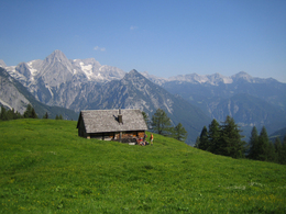
A place to take a break with an impressive mountain panorama
Before you reach the first saddle, the particularly steep "Kuhstückl" is a reminder of the arduous ascent with the cattle that were herded here until the turn of the century. At the saddle, you have reached the first half of the ascent to the alpine pasture and should definitely treat yourself to a short rest, with a detour to the rocky outcrop in front, as the view and the view down into the valley are breathtaking.
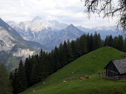
The path continues steeply and shady up through the beech forest until the forest thins out and you reach the unmanaged Hochsteinalm (at 1,296 metres above sea level) after the first open alpine meadows. The well-deserved snack stop at the (burnt down) Lögerhütte (unmanaged) is clearly visible just a few minutes' walk through the sparse larch forest. After about 600 metres in altitude, a bench in front of the alpine hut invites you to take a leisurely break, and the view of the majestic mountain giants, whose flanks are furrowed by wild valleys, is truly fascinating. After the Großer Priel (2,515 m), the dominant Spitzmauer (2,442 m) and the Ostrawitz (1,824 m) in the north-west, the Hochkästen (2,389 and 2,352 m), Brandleck (2,247 m), Turmtal, Hebenkas (2.285 m), Hochplanberg (2,229 m), Wassertal, Großer Kraxenberg (2,195 m), Schobertal, Großer Brieglersberg (2,148 m), Sigistal, Gamsspitz (2,057 m), Salzsteigjoch, Gamsstein (1,994 m) and Almkogel (2,116 m) to the south. If you look to the north-east, the Stodertal valley opens up in all its vastness at the foot of the Kleiner Priel (2,134 m). Bizarre rocks and cascading waterfalls.
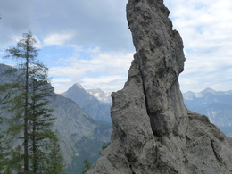
The actual Dolomite trail now begins above the Lögeralm, the next section of which requires mountain experience and a head for heights. The narrow path climbs gently up and down along steep rock faces, in trenches, over crests, past water channels and bizarre rock formations. Here it becomes clear where the Dolomite Trail gets its name from: The brittle limestone, the dolomite, with its rugged rocks and scree slopes is typical here, like something out of a geological picture book. In the increasingly rocky terrain, you approach the rope-secured descent into the Schwarzgraben and can hear the roar of the small waterfalls from afar. A second, newly created, extremely romantic variant leads directly along the Gumpenkaskaden waterfalls, which invite you to take a refreshing dip in the crystal-clear water on hot days. A leisurely descent through a unique landscape
The rest of the trail is extremely varied and less technically demanding. Unspoilt woodland, spectacular rock formations and magnificent panoramic views follow one another as you march into the valley on a gently sloping path. This beautiful passage slowly turns into a forest path, which ends abruptly below the Schwarzkogel (1,418 m) in a huge gully of gravel and rock. Here at Poppensand, the landscape changes abruptly: a dazzling white stone desert lies embedded in the nuanced green of the mountain vegetation. The trail now follows the gravel slope downhill and meets the path to the Salzsteigjoch near the Poppenalm (1,054 m). The last section of the hike leads along a forest road back to the car park at Baumschlagerreith after a total walking time of four to five hours.
Attention:
-Mountaineering boots recommended
-Alpine trail, partly secured with steel cables.
-Mountaineering experience and a head for heights required!
-Closed from 15 September to 1 October each year for hunting reasons.
further information:
- Flatly
- Board possible
The trail is especially recommended on hot days, when the crystal-clear water of the Gumpenkaskaden invites you to cool off.
Closed for hunting reasons from September 15 to October 1 of each year!
A9 to Exit St Pankraz / Hinterstoder, turn left onto B138 towards Hinterstoder; into the river sink turn towards Hinterstoder / Stodertal, follow the main road through Hinterstoder through towards the valley, follow the signs for guest house Baumschlagerreith; asphalt road to the guest house.
Paid car park
E-service station / recharging station- Charging point for e-bikes (free of charge)
- Suitable for groups
- Suitable for teenagers
- Suitable for seniors
- Suitable for single travelers
- Suitable for friends
- Suitable for couples
- Spring
- Summer
- Autumn
Please get in touch for more information.

Hinterstoder 38
4573 Hinterstoder
Phone +43 7564 5263
Fax machine +43 7564 5263 - 30
E-Mail hinterstoder@pyhrn-priel.net
Web www.urlaubsregion-pyhrn-priel.at/
You can also visit us on
Visit us on Facebook Visit us on Instagram Visit us on Pinterest Visit our videochannel on YouTube")
Interactive elevation profile
Create PDF
Tour-Details
Paths covering: