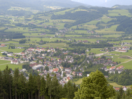
© Photo: Oberösterreich Tourismus GmbH./Robert Maybach: Enjoy the view in Upper Austria


Simberg - Wurbauerkogel


Interactive elevation profile
Create PDF
Tour-Details
Path number: 2
Starting place: 4580 Windischgarsten
Destination: 4581 Rosenau am Hengstpaß
duration: 1h 0m
length: 1,9 km
Altitude difference (uphill): 232m
Lowest point: 605m
Highest point: 837m
difficulty: easy
condition: very easy
panoramic view: Some Views
Paths covering:
Asphalt, Gravel
powered by TOURDATA
Hike from the town centre in Windischgarsten over the Simberg to the Wurbauerkogel.
Hiking trail number: 5
Starting point: Market at the Town Hall in Windischgarsten
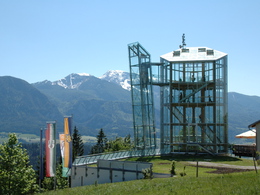
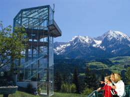
Destination: Mountain station Wurbauerkogel
further information:
- Board possible

")
Accessibility / arrival
by car:
West motorway A1 - exit Voralpenkreuz on the A9 (Pyhrnautobahn) direction Graz - exit Roßleithen / Windischgarsten
by train:
Hauptbahnhof Linz - Windischgarsten
Graz - Selzthal - Windischgarsten
Most economical season
- Summer
Please get in touch for more information.

Hauptstraße 28
4580 Windischgarsten
Phone +43 7562 5266 - 99
Fax machine +43 7562 5266 - 10
E-Mail info@pyhrn-priel.net
Web www.urlaubsregion-pyhrn-priel.at/
https://www.urlaubsregion-pyhrn-priel.at/
Interactive elevation profile
Create PDF
Tour-Details
Path number: 2
Starting place: 4580 Windischgarsten
Destination: 4581 Rosenau am Hengstpaß
duration: 1h 0m
length: 1,9 km
Altitude difference (uphill): 232m
Lowest point: 605m
Highest point: 837m
difficulty: easy
condition: very easy
panoramic view: Some Views
Paths covering:
Asphalt, Gravel
powered by TOURDATA