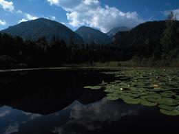
© Photo: Oberösterreich Tourismus GmbH./Robert Maybach: Enjoy the view in Upper Austria


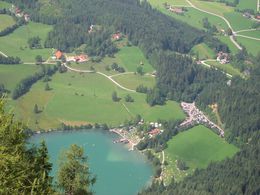
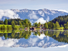
Teichl - Gleinkersee


Interactive elevation profile
Create PDF
Tour-Details
Path number: 18, 14
Starting place: 4575 Roßleithen
Destination: 4575 Roßleithen
duration: 1h 33m
length: 4,8 km
Altitude difference (uphill): 242m
Altitude difference (downhill): 11m
Lowest point: 568m
Highest point: 806m
difficulty: easy
condition: very easy
panoramic view: Great panorama
Paths covering:
Asphalt, Gravel, Hiking trail
powered by TOURDATA
Hike from Teilbrücke bridge in Roßleithen to Gleinkersee lake, a true natural jewel.
At the Teichl bridge close to the highway exit Roßleithen (bus from Windischgarsten) walk to the Seebachhof, then continue along the road slightl uphills to viewpoint Kogler – Gleinkersee access road – along trail nr. 14 to country inn Gasthaus Seebauer!Trail-Nr: 18, 14
Starting point: Teichl bridge close to the highway exit Roßleithen
Destination: Gasthaus Seebauer on Gleinkersee
further information:
- Board possible
")
Accessibility / arrival
by car:
From the north on the A9 direction Graz - exit Roßleithen,
from the south on the A9 direction Linz departure Roßleithen.
by train:
Pyhrnbahn (Linz - Graz) stop Windischgarsten
Most economical season
- Spring
- Summer
- Autumn
Please get in touch for more information.

Bahnhofstraße 2
4575 Roßleithen
Phone +43 7562 5266
Fax machine +43 7562 5266 - 10
E-Mail info@pyhrn-priel.net
Web www.urlaubsregion-pyhrn-priel.at/
https://www.urlaubsregion-pyhrn-priel.at/
Interactive elevation profile
Create PDF
Tour-Details
Path number: 18, 14
Starting place: 4575 Roßleithen
Destination: 4575 Roßleithen
duration: 1h 33m
length: 4,8 km
Altitude difference (uphill): 242m
Altitude difference (downhill): 11m
Lowest point: 568m
Highest point: 806m
difficulty: easy
condition: very easy
panoramic view: Great panorama
Paths covering:
Asphalt, Gravel, Hiking trail
powered by TOURDATA