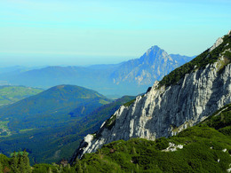
© Photo: Oberösterreich Tourismus GmbH./Robert Maybach: Enjoy the view in Upper Austria


mountain hike from lake "Taferlklaussee" to the Hochleckenhaus in Neukirchen/Altmünster


- Possible accommodation
Interactive elevation profile
Create PDF
Tour-Details
Starting place: 4814 Altmünster
Destination: 4814 Altmünster
duration: 2h 55m
length: 3,1 km
Altitude difference (uphill): 766m
Lowest point: 773m
Highest point: 1.539m
difficulty: difficult
condition: difficult
panoramic view: Great panorama
Paths covering:
Gravel, Hiking trail
powered by TOURDATA
From the first parking lot at lake Taferlklaussee forest road above a gravel pit slightly uphill. Along turns through a wooded area to a brook. Via Schüttkar steep uphill and right to Hochleckenhaus.
Difference in height: 809 m
Requirements: alpine Tour; Endurance and sure-footedness needed
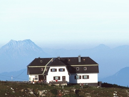
Refreshments: Hochleckenhaus (open from Easter to 26th of Octover)
Starting point: first parking place Taferlklaussee
Destination: Hochleckenhaus
further information:
- Possible accommodation
- Board possible
Accessibility / arrival
departure Regau-B145 in the direction of Bad Ischl-1km after the place name sign of Altmünster turn right in the direction of Neukirchen-Großalmstraße-Taferlklaussee/Hochlecken
Most economical season
- Spring
- Summer
- Autumn
Please get in touch for more information.
4814 Altmünster
Phone +43 7612 87181
E-Mail altmuenster@traunsee.at
Web www.traunsee.at/altmuenster
http://www.traunsee.at/altmuenster
")
Interactive elevation profile
Create PDF
Tour-Details
Starting place: 4814 Altmünster
Destination: 4814 Altmünster
duration: 2h 55m
length: 3,1 km
Altitude difference (uphill): 766m
Lowest point: 773m
Highest point: 1.539m
difficulty: difficult
condition: difficult
panoramic view: Great panorama
Paths covering:
Gravel, Hiking trail
powered by TOURDATA