© Photo: Oberösterreich Tourismus GmbH./Robert Maybach: Enjoy the view in Upper Austria


a route to the Attersee


- Flatly
Interactive elevation profile
Create PDF
Tour-Details
Starting place: 4890 Frankenmarkt
Destination: 4890 Frankenmarkt
duration: 5h 0m
length: 55,4 km
Altitude difference (uphill): 548m
Altitude difference (downhill): 548m
Lowest point: 457m
Highest point: 639m
difficulty: medium
condition: medium
panoramic view: Great panorama
Paths covering:
Asphalt
powered by TOURDATA
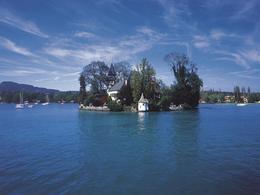
Lake Attersee, the largest inland lake in Austria, is the highlight of this circular route.
Route: Frankenmarkt R6 - Attersee R2 - connecting trail 101 via Lenzing R6 via Vöcklabruck to Frankenmarkt
Accessibility / arrival
By car:
Autobahn A1 to St.Georgen im Attergau, turn off to Frankenmarkt
By train:
West railway line to Frankenmarkt station
Most economical season
- Spring
- Summer
- Autumn
Please get in touch for more information.
Freistädterstr. 119
4890 Frankenmarkt
Phone +43 7684 6255
E-Mail office@frankenmarkt.at
Web tourismus.frankenmarkt.net
Web attersee-attergau.salzkammergut.at
http://tourismus.frankenmarkt.net
https://attersee-attergau.salzkammergut.at
https://attersee-attergau.salzkammergut.at
Interactive elevation profile
Create PDF
Tour-Details
Starting place: 4890 Frankenmarkt
Destination: 4890 Frankenmarkt
duration: 5h 0m
length: 55,4 km
Altitude difference (uphill): 548m
Altitude difference (downhill): 548m
Lowest point: 457m
Highest point: 639m
difficulty: medium
condition: medium
panoramic view: Great panorama
Paths covering:
Asphalt
powered by TOURDATA