© Photo: Oberösterreich Tourismus GmbH./Robert Maybach: Enjoy the view in Upper Austria


On the way to bathing fun


- Suitable for families
Interactive elevation profile
Create PDF
Tour-Details
Starting place: 4870 Vöcklamarkt
Destination: 4890 Frankenmarkt
duration: 0h 34m
length: 8,2 km
Altitude difference (uphill): 67m
Altitude difference (downhill): 32m
Lowest point: 485m
Highest point: 561m
difficulty: easy
condition: easy
panoramic view: Dreamtour
Paths covering:
Asphalt
powered by TOURDATA
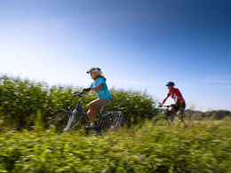
The family-friendly Roman cycle path shows us the way this time. The starting point is Vöcklamarkt railway station. We let our bikes roll through the gentle hills of the foothills of the Alps.
The blue sky arches over us and when we pedal, we feel the boundless freedom of the pedalling knights. We finally arrive in Frankenmarkt, the destination of our tour. There, the outdoor adventure pool beckons with a refreshing dip after the sporting activity. So get off your bike and into the cool water. Route: Park & ride car park at Vöcklamarkt train station - (R6) Roman cycle path - Frankenmarkt
Accessibility / arrival
by car:
West motorway A1 - exit St.Georgen, approx. 10 km to Vöcklamarkt
by train:
Westbahn - Vöcklamarkt station. Local railway connection to Attersee
Most economical season
- Summer
Please get in touch for more information.
Freistädterstr. 119
4870 Vöcklamarkt
Phone +43 7723 8555
Fax machine +43 732 7277 - 701
E-Mail info@innviertel-tourismus.at
Web www.roemerradweg.info
Web attersee-attergau.salzkammergut.at
http://www.roemerradweg.info
https://attersee-attergau.salzkammergut.at
https://attersee-attergau.salzkammergut.at
Interactive elevation profile
Create PDF
Tour-Details
Starting place: 4870 Vöcklamarkt
Destination: 4890 Frankenmarkt
duration: 0h 34m
length: 8,2 km
Altitude difference (uphill): 67m
Altitude difference (downhill): 32m
Lowest point: 485m
Highest point: 561m
difficulty: easy
condition: easy
panoramic view: Dreamtour
Paths covering:
Asphalt
powered by TOURDATA