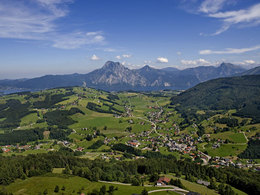
© Photo: Oberösterreich Tourismus GmbH./Robert Maybach: Enjoy the view in Upper Austria


Neukirchen-Hochkreut-Neukirchen


- Suitable for families
- Flatly
Interactive elevation profile
Create PDF
Tour-Details
Starting place: 4814 Altmünster
Destination: 4814 Altmünster
duration: 2h 29m
length: 5,4 km
Altitude difference (uphill): 400m
Altitude difference (downhill): 408m
Lowest point: 557m
Highest point: 935m
difficulty: medium
condition: medium
panoramic view: Great panorama
Paths covering:
Hiking trail
powered by TOURDATA
Neukirchen-Hochkreut-Neukirchen Circular walk
Walking time: (circular walk) approx 3 hours, difference in altitude 390 m, Level. partially steep hiking through woods
ATTENTION: Hochkreut Game Park is closed!
Starting point: church Neukirchen
Destination: Hochkreut
further information:
- Flatly
Accessibility / arrival
from the highway: departure Regau-B 145 in the direction of Bad Ischl-1 km after the place name sign "Altmünster" turn right in the direction of Neukirchen
- Suitable for groups
- Suitable for schools
- Suitable for families
- Spring
- Summer
- Autumn
Please get in touch for more information.
4814 Altmünster
Phone +43 7612 87181
E-Mail altmuenster@traunsee.at
Web www.traunsee.at/altmuenster
http://www.traunsee.at/altmuenster
Interactive elevation profile
Create PDF
Tour-Details
Starting place: 4814 Altmünster
Destination: 4814 Altmünster
duration: 2h 29m
length: 5,4 km
Altitude difference (uphill): 400m
Altitude difference (downhill): 408m
Lowest point: 557m
Highest point: 935m
difficulty: medium
condition: medium
panoramic view: Great panorama
Paths covering:
Hiking trail
powered by TOURDATA