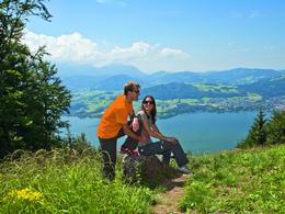
© Photo: Oberösterreich Tourismus GmbH./Robert Maybach: Enjoy the view in Upper Austria


Grünbergweg in Gmunden


Interactive elevation profile
Create PDF
Tour-Details
Starting place: 4810 Gmunden
Destination: 4810 Gmunden
duration: 2h 1m
length: 2,6 km
Altitude difference (uphill): 513m
Lowest point: 435m
Highest point: 947m
difficulty: medium
condition: medium
panoramic view: Great panorama
Paths covering:
Hiking trail
powered by TOURDATA
Starting point is the parking lot of the cable car "Grünberg" in Gmunden.
Gsperrstraße-Moosbergweg-stairs up to Silberroith-cross the Mitterweg-sunken road of the farmer "Grünbergbauer"-Tiefau-through the forest or across the slope-"Schneewiese"-under the cable car till the top of the mountain "Grünberg" Starting point: parking lot cable car Grünberg
Destination: Grünberg
")
Accessibility / arrival
from the highway: departure Regau- B 145 in the direction of Bad Ischl- through the center of Gmunden-across the bridge- turn right to the cable car "Grünberg"
Most economical season
- Summer
Please get in touch for more information.
Toscanapark 1
4810 Gmunden
Phone +43 7612 74451
E-Mail info@traunsee-almtal.at
Web www.traunsee-almtal.at
http://www.traunsee-almtal.at
Interactive elevation profile
Create PDF
Tour-Details
Starting place: 4810 Gmunden
Destination: 4810 Gmunden
duration: 2h 1m
length: 2,6 km
Altitude difference (uphill): 513m
Lowest point: 435m
Highest point: 947m
difficulty: medium
condition: medium
panoramic view: Great panorama
Paths covering:
Hiking trail
powered by TOURDATA