© Photo: Oberösterreich Tourismus GmbH./Robert Maybach: Enjoy the view in Upper Austria


Hütteneckalm


- culinary interesting
- Flatly
Interactive elevation profile
Create PDF
Tour-Details
Starting place: 4820 Bad Ischl
Destination: 4820 Bad Ischl
duration: 4h 36m
length: 9,8 km
Altitude difference (uphill): 754m
Altitude difference (downhill): 749m
Lowest point: 623m
Highest point: 1.288m
difficulty: medium
condition: medium
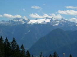
panoramic view: Great panorama
Paths covering:
Hiking trail
powered by TOURDATA
Hike to a mountain inn with lovely views of the Dachstein.
Starting point: Parking at the salt mine in Perneck (47 ° 41'05 "N - 13 ° 38'50 " E - 620 m). Directions: From the centre south into Grazerstraße. After house number 49, at a crossroads turn left at the second road (Perneckerstraße) follow this to the end.
Destination: Parking at the salt mine in Perneck (47 ° 41'05 "N - 13 ° 38'50 " E - 620 m).
further information:
- culinary interesting
- Flatly
- Board possible
Most economical season
- Spring
- Summer
- Autumn
Please get in touch for more information.
4820 Bad Ischl
Phone +43 6132 27757
E-Mail office@badischl.at
Web www.badischl.at
http://www.badischl.at
Interactive elevation profile
Create PDF
Tour-Details
Starting place: 4820 Bad Ischl
Destination: 4820 Bad Ischl
duration: 4h 36m
length: 9,8 km
Altitude difference (uphill): 754m
Altitude difference (downhill): 749m
Lowest point: 623m
Highest point: 1.288m
difficulty: medium
condition: medium
panoramic view: Great panorama
Paths covering:
Hiking trail
powered by TOURDATA