

Gasthof Post round


- pets allowed
- All weather
- Suitable for families
Interactive elevation profile
Create PDF
Tour-Details
Paths covering:
Running and Nordic walking route along Lake Hallstatt
Varied running and Nordic walking route on Lake Hallstatt
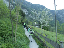
Start in Au at the Volksbank, along Arikoglstrasse to Obersee along the lakeshore to Uferwirt Seeraunzn. After a slight ascent, you return to Untersee on the road, continuing along Manneckweg and Saugasse to the starting point in Au.Right next to the starting point is the Gasthof "Zur Post" where you can fortify yourself in the cosy guest garden or conservatory.
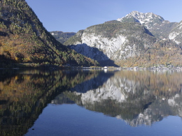
Enjoy the impressive views of the mountains and the Hallstättersee.
This route is also possible in winter.
Length 9.7 km 115 metres altitude
The loop is signposted with green marker boards.
In emergencies, call the mountain rescue service on 140.
Experience a 360° panoramic tour through Bad Goisern on Lake Hallstatt...
further information:
- Board possible
The tour is possible all year round.
The Gasthof Post tour starts at the Gasthof zur Post in the village of Au.
From Bad Goisern on the B 166 towards Hallstatt/Gosau.
By car
From Salzburg:
Exit Thalgau via the B158 federal road towards Bad Ischl, in Bad Ischl take the B145 Salzkammergut road towards Bad Goisern.
From Linz:
Regau motorway exit onto Salzkammergut Straße B145 towards Gmunden and Bad Ischl to Bad Goisern.
From Vienna/Graz:
Liezen motorway exit onto B320, in Trautenfels turn off onto Salzkammergut Straße B145 to Bad Goisern.
From Villach:
Tauern motorway to exit "Eben im Pongau", via B166 Pass Gschütt Bundesstraße through Gosau, turn left at the Gosaumühle junction towards Bad Goisern.
By train
Train Attnang-Puchheim - Stainach-Irdning:
Stops Goisern Jodschwefelbad, Bad Goisern railway station, Steeg / Gosau.
By bus
Bus 541 & 542 (Bad Ischl - Lake Gosau):
Stops Bad Goisern Jodschwefelbad, Bad Goisern Kurhotel, Bad Goisern Mitte/B145, Stambach StrKrzg., St. Agatha Agathawirt, Stambach Angerer, Steeg Reitern, Steeg Au, Steeg Bahnhof, Steeg Traunbrücke, Steeg E-Werk.
Detailed information on the respective Train- and Bus times can be found here!
- Parking space: 10
- All weather
- Suitable for groups
- Suitable for schools
- Pets allowed
- Suitable for single travelers
- Suitable for families
- Suitable for friends
- Suitable for couples
- Spring
- Summer
- Autumn
- Early winter
Please get in touch for more information.
Kirchengasse 4
4822 Bad Goisern am Hallstättersee
Phone +43 5 95095 - 10
E-Mail info@dachstein-salzkammergut.at
Web dachstein.salzkammergut.at
You can also visit us on
Visit us on Facebook Visit us on Instagram Visit us on TikTok Visit us on Pinterest Visit our videochannel on YouTube WikipediaInteractive elevation profile
Create PDF
Tour-Details
Paths covering: