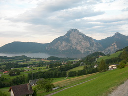
© Photo: Oberösterreich Tourismus GmbH./Robert Maybach: Enjoy the view in Upper Austria


Aurachtal-Loop


- Flatly
Interactive elevation profile
Create PDF
Tour-Details
Starting place: 4813 Altmünster
Destination: 4813 Altmünster
duration: 2h 30m
length: 22,5 km
Altitude difference (uphill): 466m
Altitude difference (downhill): 466m
Lowest point: 431m
Highest point: 728m
difficulty: easy
condition: medium
panoramic view: Great panorama
Paths covering:
Asphalt
powered by TOURDATA
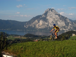
This loop starts at the lake promenade in Altmünster and leads via Grasberg and Neukirchen into the valley of the River Aurach. The highest point of this 23–kilometer long trail through the Traunsee holiday region is at 733 meters above sea level. The route returns back via Pinsdorf.
Start: lake promenade in Altmünster - Bahnhofstraße to Edter junction - left, right, steep uphill to the roadside cavalry - left to Gasthof Reschenwirt: highest point (733m) - side road to Neukirchen - right towards the center of town - right to Reindlmühl and through town - along the river shores to Pinsdorf - Steinbichlerweg towards Altmünster - across the rail tracks, along Hatschekstraße, through Kinderdorfstraße, Pensionatsstraße, Dr.Thomas Straße, to the lake promenade. (Further information: Schubert & Franzke, Salzkammergut Mountain Biking, mountain bike map 1:50000) Starting point: lake promenade Altmünster
Destination: lake promenade Altmünster
further information:
- Flatly
details mountainbike
- Riding technique: very easy
Accessibility / arrival
from the highway: departure Regau-B 145 in the direction of Nad Ischl- 200m after the place name sign "Altmünster" begins on the right side the promenade
Most economical season
- Spring
- Summer
- Autumn
Please get in touch for more information.
4813 Altmünster
Phone +43 7612 87181
E-Mail info@traunsee-almtal.at
Web www.traunsee-almtal.at/altmuenster
http://www.traunsee-almtal.at/altmuenster
Interactive elevation profile
Create PDF
Tour-Details
Starting place: 4813 Altmünster
Destination: 4813 Altmünster
duration: 2h 30m
length: 22,5 km
Altitude difference (uphill): 466m
Altitude difference (downhill): 466m
Lowest point: 431m
Highest point: 728m
difficulty: easy
condition: medium
panoramic view: Great panorama
Paths covering:
Asphalt
powered by TOURDATA