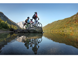
© Photo: Oberösterreich Tourismus GmbH./Robert Maybach: Enjoy the view in Upper Austria


Cycling trail to the lakes "Langbathseen" and back


Interactive elevation profile
Create PDF
Tour-Details
Starting place: 4802 Ebensee
Destination: 4802 Ebensee
duration: 1h 2m
length: 8,4 km
Altitude difference (uphill): 387m
Altitude difference (downhill): 142m
Lowest point: 430m
Highest point: 701m
difficulty: medium
condition: medium
panoramic view: Great panorama
Paths covering:
Asphalt, Gravel
powered by TOURDATA
Starting point of this tour is the center of Ebensee.
Ebensee-road Langbathstraße-cable car station Feuerkogel-along the rivulet "Langbathbach"-after 4 km turn left into a forest road or along the road Langbathstraße till the Langbathseen.Enjoy the impressive panorama of the two lakes.
After a break you have to drive back the same route till the starting point.
Starting point: center of Ebensee
Destination: center of Ebensee

")
Accessibility / arrival
from the highway: departure Regau-B 145 in the direction of Bad Ischl-turn right into the center of Ebensee
Most economical season
- Spring
- Summer
- Autumn
Please get in touch for more information.
Hauptstraße 34
4802 Ebensee
Phone +43 6133 8016
E-Mail ebensee@traunsee-almtal.at
Web www.traunsee-almtal.at/ebensee
http://www.traunsee-almtal.at/ebensee
Interactive elevation profile
Create PDF
Tour-Details
Starting place: 4802 Ebensee
Destination: 4802 Ebensee
duration: 1h 2m
length: 8,4 km
Altitude difference (uphill): 387m
Altitude difference (downhill): 142m
Lowest point: 430m
Highest point: 701m
difficulty: medium
condition: medium
panoramic view: Great panorama
Paths covering:
Asphalt, Gravel
powered by TOURDATA