© Photo: Oberösterreich Tourismus GmbH./Robert Maybach: Enjoy the view in Upper Austria


circular walking route Hofgraben/Buchberg


- Flatly
Interactive elevation profile
Create PDF
Tour-Details
Starting place: 4801 Traunkirchen
Destination: 4801 Traunkirchen
duration: 1h 0m
length: 3,4 km
Altitude difference (uphill): 85m
Altitude difference (downhill): 85m
Lowest point: 439m
Highest point: 476m
difficulty: easy
condition: easy
panoramic view: Individual Views
Paths covering:
Gravel, Hiking trail
powered by TOURDATA
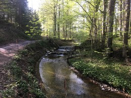
Easy hiking tour Hofgraben/Buchberg.
Walking time: approx. 1 hour
starting point: Traunkirchen Bahnhof (train station)
Starting point: train station Traunkirchen
Destination: train station Traunkirchen
further information:
- Flatly
Most economical season
- Spring
- Summer
- Autumn
- Early winter
Please get in touch for more information.
Ortsplatz 1
4801 Traunkirchen
Phone +43 7617 2255
E-Mail gemeindeamt@traunkirchen.ooe.gv.at
Web www.traunsee.at/traunkirchen
http://www.traunsee.at/traunkirchen
Interactive elevation profile
Create PDF
Tour-Details
Starting place: 4801 Traunkirchen
Destination: 4801 Traunkirchen
duration: 1h 0m
length: 3,4 km
Altitude difference (uphill): 85m
Altitude difference (downhill): 85m
Lowest point: 439m
Highest point: 476m
difficulty: easy
condition: easy
panoramic view: Individual Views
Paths covering:
Gravel, Hiking trail
powered by TOURDATA