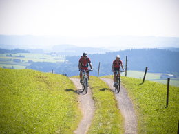
© Photo: Oberösterreich Tourismus GmbH./Robert Maybach: Enjoy the view in Upper Austria


Hansbergland-Südrunde


- Flatly
Interactive elevation profile
Create PDF
Tour-Details
Path number: 5
Starting place: 4171 St. Peter am Wimberg
Destination: 4171 St. Peter am Wimberg
duration: 5h 8m
length: 61,0 km
Altitude difference (uphill): 1.328m
Altitude difference (downhill): 1.328m
Lowest point: 429m
Highest point: 825m
difficulty: medium
condition: medium
panoramic view: Some Views
Paths covering:
Asphalt, Street, Hiking trail
powered by TOURDATA
Mountain biking in the south of the Hansbergland.
Map available at the market town office or for download at www.granitland.at
further information:
- Flatly
details mountainbike
- Riding technique: medium
E-service station / recharging station
- Charging point for electric cars (free of charge)
- Suitable for teenagers
- Suitable for single travelers
- Suitable for friends
- Suitable for couples
- Spring
- Summer
- Autumn
Please get in touch for more information.
Markt 2
4171 St. Peter am Wimberg
Phone +43 7282 8055 - 0
Fax machine +43 7282 8055 - 22
E-Mail gemeinde@st-peter.at
Web www.st-peter.at
Web www.granitland.at
https://www.st-peter.at
https://www.granitland.at
https://www.granitland.at
Interactive elevation profile
Create PDF
Tour-Details
Path number: 5
Starting place: 4171 St. Peter am Wimberg
Destination: 4171 St. Peter am Wimberg
duration: 5h 8m
length: 61,0 km
Altitude difference (uphill): 1.328m
Altitude difference (downhill): 1.328m
Lowest point: 429m
Highest point: 825m
difficulty: medium
condition: medium
panoramic view: Some Views
Paths covering:
Asphalt, Street, Hiking trail
powered by TOURDATA