© Photo: Oberösterreich Tourismus GmbH./Robert Maybach: Enjoy the view in Upper Austria


Traunstein - Hernlersteig


Interactive elevation profile
Create PDF
Tour-Details
Starting place: 4810 Gmunden
Destination: 4810 Gmunden
duration: 4h 7m
length: 2,3 km
Altitude difference (uphill): 1.144m
Altitude difference (downhill): 29m
Lowest point: 468m
Highest point: 1.588m
difficulty: difficult
condition: difficult
panoramic view: Some Views
Paths covering:
Climbing mount
powered by TOURDATA
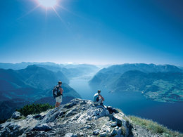
Wonderful via ferrata above the shores of Lake Traunsee!
●W 416: Hernlersteig: walking time: 2 ½ -3 hours, difference in altitude 1269 m 4110/5303 300m before return point (Bründl)- Traunsteinplateau (power place pictogram)Refreshment stops: Gh Hois'n, Mair-Alm, Gmundner Hütte and Traunsteinhaus
Gmundner Hütte: (1,666m) - Austrian Alpine Club
Mr Gerald Auinger, Tel. 0699/12643190
Overnight accommodation (34 campsites)
http://free.pages.at/traunstein
Good physical condition and a head for heights are basic requirements to enjoy a beautiful tour on the Traunstein!
Traunsee via ferrata
Since 2006, the ascent via the Hernlersteig has offered the option of climbing the top 150 metres of altitude via the new Traunsee via ferrata. The Traunsee via ferrata is a difficult sport via ferrata (rated D), which is very well secured with a continuous wire rope and footholds. The entrance is located in the upper part of the Hernlersteig at the end of the so-called Brandgraben at an altitude of 1500 metres above sea level. After around 30 to 40 minutes of climbing, some of which is challenging, with fantastic and very airy views down to Lake Traunsee, you reach the guest garden of the Gmundnerhütte.
The via ferrata should only be attempted with appropriate climbing equipment (hip belt, via ferrata set and rockfall helmet).
- Suitable for kids (13 - 14 Year)
- Suitable for single travelers
- Suitable for friends
- Suitable for couples
- Summer
Please get in touch for more information.
Badgasse 6
4810 Gmunden
Phone +43 7612 74451
E-Mail info@traunsee-almtal.at
Web www.traunsee-almtal.at
http://www.traunsee-almtal.at
Interactive elevation profile
Create PDF
Tour-Details
Starting place: 4810 Gmunden
Destination: 4810 Gmunden
duration: 4h 7m
length: 2,3 km
Altitude difference (uphill): 1.144m
Altitude difference (downhill): 29m
Lowest point: 468m
Highest point: 1.588m
difficulty: difficult
condition: difficult
panoramic view: Some Views
Paths covering:
Climbing mount
powered by TOURDATA