© Photo: Oberösterreich Tourismus GmbH./Robert Maybach: Enjoy the view in Upper Austria


Jubiläumsweg


Interactive elevation profile
Create PDF
Tour-Details
Starting place: 4802 Ebensee
Destination: 4802 Ebensee
duration: 0h 34m
length: 2,3 km
Altitude difference (uphill): 11m
Lowest point: 424m
Highest point: 436m
difficulty: easy
condition: easy
panoramic view: Some Views
Paths covering:
Hiking trail
powered by TOURDATA
The district of Rindbach was the centre of the summer resort in Ebensee in the 20th century.
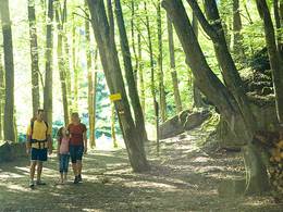
During the summer months, Rindbach was a favourite retreat for famous artists and bankers, who also left their mark.At the junction of Rindbachstraße and Alte Traunstraße, a narrow path branches off, the Schöffauweg. It leads across meadows through a scattered settlement to Mendelssohnstraße. A short ascent on this road, past the "Fichteneck", leads to a forest road that branches off to the right. Turn right again onto a forest path that climbs slightly. Benches set up along the Jubiläumsweg invite you to linger. The path leads over bridges to a vantage point from which Ebensee and Lake Traunsee lie before you. The valley floor is reached via a few hairpin bends. Cross the Alte Traun and walk back to the starting point of the anniversary trail for 20 minutes along the Alte Traunstraße.
Walking time: Crossing Rindbachstraße- Alte Traunstraße: approx. 1 1/4 hours
Most economical season
- Spring
- Summer
- Autumn
Please get in touch for more information.
4802 Ebensee
Phone +43 6133 8016
E-Mail ebensee@traunsee.at
Web www.traunsee.at/ebensee
http://www.traunsee.at/ebensee
Interactive elevation profile
Create PDF
Tour-Details
Starting place: 4802 Ebensee
Destination: 4802 Ebensee
duration: 0h 34m
length: 2,3 km
Altitude difference (uphill): 11m
Lowest point: 424m
Highest point: 436m
difficulty: easy
condition: easy
panoramic view: Some Views
Paths covering:
Hiking trail
powered by TOURDATA