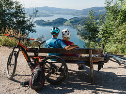
© Photo: Oberösterreich Tourismus GmbH./Robert Maybach: Enjoy the view in Upper Austria


To the Eisenau Alp


Interactive elevation profile
Create PDF
Tour-Details
Starting place: 5310 Mondsee am Mondsee
Destination: 5310 Mondsee am Mondsee
duration: 2h 30m
length: 32,2 km
Altitude difference (uphill): 544m
Altitude difference (downhill): 544m
Lowest point: 480m
Highest point: 1.024m
difficulty: medium
condition: difficult
panoramic view: Some Views
Paths covering:
Asphalt, Gravel
powered by TOURDATA
Starting point is the parking south at the beach volleyball court in Mondsee.
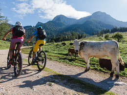
From here follow the quayside till you reach Schwarzindien. The tour passes the famous dragonwall and leads along the Mondsee lake. At the villlage of Scharfling turn to the right until you reach a gravel road on the left. It is situated just before the tarmac road starts to increase sharply.Follow the gravel road uphill until you reach the Eisenau Alp after some kilometers.
Are you able to cycle through all the way uphill? Even the best local biker have to dismount at one specific point. No worry it is only about 50m to push. Afterwards you really earn a cold drink at the mountain snack bar.
further information:
- Board possible
details mountainbike
- Riding technique: medium
Most economical season
- Spring
- Summer
- Autumn
Please get in touch for more information.

Dr. Franz Müller Straße 3
5310 Mondsee am Mondsee
Phone +43 6232 2270
Fax machine +43 6232 2270 - 22
E-Mail info@mondsee.at
Web mondsee.salzkammergut.at
https://mondsee.salzkammergut.at
Interactive elevation profile
Create PDF
Tour-Details
Starting place: 5310 Mondsee am Mondsee
Destination: 5310 Mondsee am Mondsee
duration: 2h 30m
length: 32,2 km
Altitude difference (uphill): 544m
Altitude difference (downhill): 544m
Lowest point: 480m
Highest point: 1.024m
difficulty: medium
condition: difficult
panoramic view: Some Views
Paths covering:
Asphalt, Gravel
powered by TOURDATA