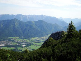
Hainzen (1638 m) - Elferkogel (1601 m) and Katrin (1542 m)
Starting place: 4820 Bad Ischl
Destination: 4820 Bad Ischl
7 Lake-View Walk
Difference in altitude: 400 m ascent, descent 400 m
Requirements: The ascent to Hainzen requires sure-footedness.
Versions: the direct ascent to the Katrin is relatively easy to do in 40 minutes
It is advised to follow the recommended walking direction.
From the top cable car station walk 100m southwest to the mountain rescue hut to a junction with signposts. Here keep left .At first the path is wide then narrows and becomes steep, there is a fixed line for safety. The path snakes up the hill. After a good 30 minute walk it reaches an intersection
(47 ° 41'13 "N - 013 ° 34'28 " E- 1550 m). At this point the walk can be reduced by going right, reaching the Elferkogel in 10 minutes. The main trail goes left and reaches another intersection after 15 minutes (47 ° 41'20 "N - 013 ° 34'15 " E - 1610 m). Keep left and in about 20 minutes the trail reaches the top of Hainzen (47 ° 41'13 "N - 013 ° 34'00 " E - 1638 m). From here there are magnificent views in every direction. To descend follow the same trail back to the last signpost. At the signpost go left and the path rises and falls over the plateau to the east. The next intersection is at the summit cross of the Elferkogel (47 ° 41'15 "N - 013 ° 34'38 " E -1601 m). From here descend towards the east for 10 minutes to reach an intersection (47 ° 41'18 " N 013 ° 34'47 " E - 1550 m) with the direct uphill route from the cable car station. At this point you can descend to the right, back to the cable car station. Alternatively from here it is a 5 minute walk to the magnificent summit cross on the Katrin from which there are views over Bad Ischl. Return on the same path for 5 minutes and keep straight on. After a flat area it is possible to see the cable car station again and the end of the trail.
Starting place: 4820 Bad Ischl
Destination: 4820 Bad Ischl
duration: 1h 50m
length: 2,7 km
Altitude difference (uphill): 331m
Altitude difference (downhill): 332m
Lowest point: 1.411m
Highest point: 1.587m
difficulty: medium
condition: medium
panoramic view: Dreamtour
Paths covering:
Hiking trail
Starting point: Starting point: mountain station of the Katrinseilbahn (cable car) Katrin (47 ° 41'09 "N -13 ° 34'58 " E - 1415 m). Directions: From the centre of Bad Ischl follow signs for “Katrinseilbahn” Parking (surcharge) (47 ° 41'54 "N - 013 ° 36'27 " E) The cable car is also accessible by public transport (city line). Take the cable car to the top of the Katrinalm (operating May to October) or walk on Tour No. 16 to the Alm.
Destination: As a starting point - round trip
further information:
- Flatly
- Board possible
Most economical season
- Spring
- Summer
- Autumn
Please get in touch for more information.
4820 Bad Ischl
Phone +43 6132 27757
Fax machine +43 6132 27757 - 77
E-Mail office@badischl.at
Web www.badischl.at
http://www.badischl.at


