© Photo: Oberösterreich Tourismus GmbH./Robert Maybach: Enjoy the view in Upper Austria


Red Trail - Let the scythes show you the way in Roßleithen


- Suitable for pushchairs
Interactive elevation profile
Create PDF
Tour-Details
Starting place: 4575 Roßleithen
Destination: 4575 Roßleithen
duration: 0h 48m
length: 2,6 km
Altitude difference (uphill): 84m
Altitude difference (downhill): 82m
Lowest point: 673m
Highest point: 735m
difficulty: very easy
condition: easy
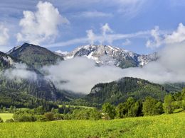
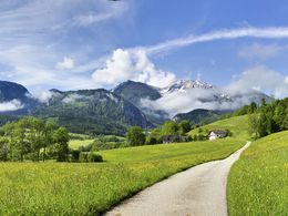
panoramic view: Great panorama
Paths covering:
Asphalt, Hiking trail
powered by TOURDATA
Red scythe theme trail: circular route approx. 1 hour walking time!
The "Red Scythe Theme Trail" is initially the same as the "Blue Scythe Theme Trail". At the Gallbrunn snack bar, this branches off uphill, via a meadow path to the Schweizersberg supply road. Now follow this down the valley to the starting point at the hiking car park.Magnificent views of many mountain peaks in the region are described on informative pictures.
Small "red scythes" show them the way!
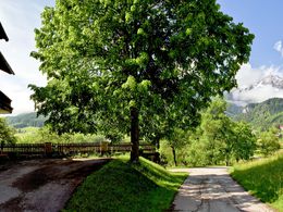
Starting point: Hiking car park in the center of Roßleithen
Destination: Hiking car park in the center of Roßleithen
further information:
- Board possible
Details - hiking
- themed path
")
Accessibility / arrival
Hiking car park in the center of Roßleithen
- Suitable for pushchairs
- Summer
Somewhat suitable for wheelchairs: Assistance is sometimes necessary. The measurements do not (fully) conform to the legally stipulated ÖNORM.

Hauptstraße 28
4575 Roßleithen
Phone +43 7562 5266 - 99
Fax machine +43 7562 5266 - 10
E-Mail info@pyhrn-priel.net
Web www.urlaubsregion-pyhrn-priel.at
https://www.urlaubsregion-pyhrn-priel.at
Interactive elevation profile
Create PDF
Tour-Details
Starting place: 4575 Roßleithen
Destination: 4575 Roßleithen
duration: 0h 48m
length: 2,6 km
Altitude difference (uphill): 84m
Altitude difference (downhill): 82m
Lowest point: 673m
Highest point: 735m
difficulty: very easy
condition: easy
panoramic view: Great panorama
Paths covering:
Asphalt, Hiking trail
powered by TOURDATA