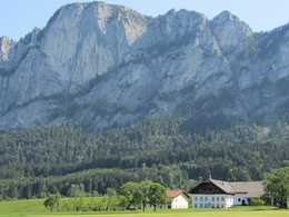
© Photo: Oberösterreich Tourismus GmbH./Robert Maybach: Enjoy the view in Upper Austria


Höribach - Wagnermühle - Schwarzindien


- All weather
- Suitable for families
- Suitable for pushchairs
- Suitable for kids (all ages)
- culturally interesting
- Flatly
Interactive elevation profile
Create PDF
Tour-Details
Starting place: 5310 Mondsee am Mondsee
Destination: 5310 Mondsee am Mondsee
duration: 2h 20m
length: 9,2 km
Altitude difference (uphill): 72m
Altitude difference (downhill): 66m
Lowest point: 480m
Highest point: 536m
difficulty: medium
condition: medium
panoramic view: Individual Views
Paths covering:
Asphalt, Hiking trail
powered by TOURDATA
Discover the traces of the "Salzkammergut Lokalbahn"
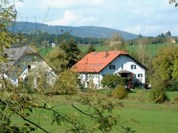
We walk through Alleestraße to the lake, keep right, walk past the Alpenseebad and the parking lot to Mondseestraße, which we follow. After the parking lot at the Sparmarkt, path no.10 to the Schober is marked. We go this way. The main road is crossed in Höribach. The footpath up the hill leads past the Höribachhof on the right. We continue on the Höribachstraße over the ridge, at the fork to the right and downhill again. At the house at Höribachstraße 100 we leave path no.10 and turn left. We hike on the former railway line to the Wagner mill, where we meet the road to St. Lorenz. We turn left, but do not go to the main road, but turn left again immediately. After entering the Camaro company, the bike path and footpath turn right towards Mondsee. On this path we pass under the main road and reach "Schwarzindien" (Black India), where we turn left (path no. 34). Through the settlement area on the bank it goes back to Mondseestrasse and along this. After the Hotel Lackner, we can go left over Matthäus-Much-Straße to Rainerstraße and back to the center. This path has only a small incline over the Höribach ridge. about half of the way leads along the former railway line. The Salzkammergut local railway ran from Salzburg via St. Lorenz to Bad Ischl. A branch line led from St. Lorenz via Black India and Leitnerbräukeller (today Hotel Lackner) to Mondsee.
This tour including a description was made available to us by the Alpenverein Österreich, Mondsee Section, Mrs. Annelu-Ilse Wenter.
This tour including a description was made available to us by the Alpenverein Österreich, Mondsee Section, Mrs. Annelu-Ilse Wenter.
Starting point: Tourism Association Mondsee-Irrsee, Dr. Franz Müller Str. 3 - in the center of Mondsee. Parking at the lake promenade!
Destination: Tourism Association Mondsee-Irrsee, Dr. Franz Müller Str. 3 - in the center of Mondsee.
further information:
- Flatly
")


")
Accessibility / arrival
The tour starts at the Mondsee-Irrsee tourist office in the center of Mondsee. Free parking is available at the Mondsee lake promenade.
- Parking space: 100
none
- All weather
- Suitable for groups
- Suitable for kids (all ages)
- Suitable for pushchairs
- Suitable for seniors
- Suitable for single travelers
- Suitable for families
- Suitable for friends
- Suitable for couples
- Suitable for children
- Spring
- Summer
- Autumn
- Early winter
- Deep winter
Please get in touch for more information.
Dr. Franz Müller Straße 3
5310 Mondsee am Mondsee
Phone +43 6232 2270
E-Mail info@mondsee.at
Web mondsee.salzkammergut.at
https://mondsee.salzkammergut.at
Interactive elevation profile
Create PDF
Tour-Details
Starting place: 5310 Mondsee am Mondsee
Destination: 5310 Mondsee am Mondsee
duration: 2h 20m
length: 9,2 km
Altitude difference (uphill): 72m
Altitude difference (downhill): 66m
Lowest point: 480m
Highest point: 536m
difficulty: medium
condition: medium
panoramic view: Individual Views
Paths covering:
Asphalt, Hiking trail
powered by TOURDATA