

Laudachsee-Grünberg - Sport Run Gilles Runde by Runnersfun


- pets allowed
- All weather
Interactive elevation profile
Create PDF
Tour-Details
Paths covering:
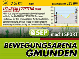
GMUNDEN - SEP macht Sport Bewegungsarena
The Bewegungsarena Gmunden flyer with map is available from the guest centre of the Traunsee-Almtal tourist office at Toscanapark 1.Not too long and yet very varied, the G9a TRAUNSEE TOURISTIK circuit connects the Laudachsee with the Grünberg summit. On a continuous gravel surface, initially downhill and towards the end with a challenging climb to the Grünberg panorama board.
year-round, caution in snow - possibly dangerous ice
From Salzburg on the motorway A1 to Regau, take the Salzkammergut B145 road towards Gmunden, Altmünster, Ebensee. From Vienna on the motorway A1 to the Laakirchen West exit, take the B144 towards Gmunden and Traunsee Holiday Region (Vorchdorf, Laakrichen East, Regau exit are also options). From Passau on the motorway A8 to Wels motorway interchange, towards Graz/Salzburg until the Voralpenkreuz motorway interchange towards Salzburg on motorway A1 to the Laakirchen West exits, take the B144 to Gmunden and Traunsee Holiday Region (Vorchdorf, Laakirchen East, Regau exits are options).
free
- All weather
- Suitable for schools
- Pets allowed
- Spring
- Summer
- Autumn
- Early winter
Please get in touch for more information.

Toscanapark 1
4810 Gmunden
Phone +43 7612 74451
E-Mail office@runnersfun.com
Web www.traunsee-almtal.at
Web www.runnersfun.com
http://www.runnersfun.com
You can also visit us on
Visit us on FacebookInteractive elevation profile
Create PDF
Tour-Details
Paths covering: