© Photo: Oberösterreich Tourismus GmbH./Robert Maybach: Enjoy the view in Upper Austria


Wurzeralm - Dümlerhütte - Wurzeralm


- Flatly
Interactive elevation profile
Create PDF
Tour-Details
Path number: 218, 293, 201
Starting place: 4582 Spital am Pyhrn
Destination: 4582 Spital am Pyhrn
duration: 5h 7m
length: 10,1 km
Altitude difference (uphill): 856m
Altitude difference (downhill): 855m
Lowest point: 1.356m
Highest point: 1.895m
difficulty: medium
condition: medium
panoramic view: Great panorama
Paths covering:
Gravel, Hiking trail
powered by TOURDATA
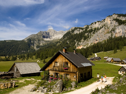
Circular hike from the Wurzeralm mountain station via the Halssattel to the Dümlerhütte and back to the Rote Wand saddle and Brunnsteinersee lake to the Wurzeralm funicular mountain station.
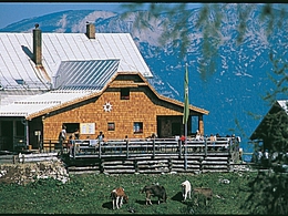
You now cross the forest road a few times before the hiking trail leads left up to the Halssattel. Here you have a wonderful panorama. Now it goes downhill and then uphill again to the Dümlerhütte. Take a break and let your gaze wander over the surrounding mountains.
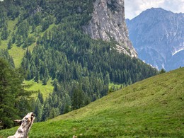
After a breather, climb northwards along the edge of the Stofferkar to the saddle of the Rote Wand. A magnificent view of the Wurzeralm, the Gesäuse and the Rottenmanner Tauern will delight many hiker's heart!
The descent is via the small, idyllic Brunnsteinersee lake. Finally, you reach hiking trail number 201, which leads back to the Wurzeralm funicular railway via the Linzerhaus.
Starting point: Wurzeralm funicular top station
Destination: Wurzeralm funicular top station
further information:
- Flatly
- Board possible
")


")
")
")

")
")
Accessibility / arrival
Parking Wurzeralm base station and funicular ride up the funicular.
- Suitable for teenagers
- Suitable for seniors
- Suitable for single travelers
- Suitable for friends
- Suitable for couples
- Spring
- Summer
- Autumn
Please get in touch for more information.

Stiftsplatz 7
4582 Spital am Pyhrn
Phone +43 7563 249 - 99
Fax machine +43 7563 249 - 20
E-Mail spital@pyhrn-priel.net
Web www.urlaubsregion-pyhrn-priel.at
https://www.urlaubsregion-pyhrn-priel.at

")
Interactive elevation profile
Create PDF
Tour-Details
Path number: 218, 293, 201
Starting place: 4582 Spital am Pyhrn
Destination: 4582 Spital am Pyhrn
duration: 5h 7m
length: 10,1 km
Altitude difference (uphill): 856m
Altitude difference (downhill): 855m
Lowest point: 1.356m
Highest point: 1.895m
difficulty: medium
condition: medium
panoramic view: Great panorama
Paths covering:
Gravel, Hiking trail
powered by TOURDATA