© Photo: Oberösterreich Tourismus GmbH./Robert Maybach: Enjoy the view in Upper Austria


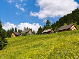
Gammeringalmen of the Wurzeralm mountain station to the base station


Interactive elevation profile
Create PDF
Tour-Details
Starting place: 4582 Spital am Pyhrn
Destination: 4582 Spital am Pyhrn
duration: 2h 26m
length: 6,4 km
Altitude difference (uphill): 204m
Altitude difference (downhill): 801m
Lowest point: 813m
Highest point: 1.596m
difficulty: easy
condition: easy
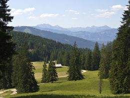
panoramic view: Great panorama
Paths covering:
Hiking trail
powered by TOURDATA
Hike from the mountain station to the Wurzeralm Standseibahn Gammeringsattel and the Gammeringalmen and through the plaster digging for Wurzeralm funicular base station.
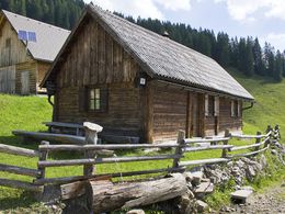
From the mountain station of the Wurzeralm Standseibahn you walk straight down to the transformer and go right past the way up through the forest to. When you come out of the woods out you are already on the slopes of Hahnlgraben.Turn left, following the path of the runway up to the Gammeringsattel where you already have a beautiful view of the mountains of Styria's Enns Valley. The road leads past the Krennbauernalm in the first Wegabzweigung go straight on and at the next fork to the left Gammeringalmen.
Then you come to the so-called "Christl chute" where the road branched several times. You walk down the street to the left and at the next junction, go right.
After about 50 meters turn left and follow the path along the runway in the always shady gypsum trench. This hike along until you reach the road next to the funicular. Now right and follow the road to the valley station of the funicular Wurzeralm.
Starting point: Mountain station Wurzeralm funicular in Spital am Pyhrn
Destination: Valley Station Wurzeralm funicular in Spital am Pyhrn
further information:
- Board possible
")
Accessibility / arrival
Parking Wurzeralm valley station and continue with the Wurzeralm funicular to the starting point!
Most economical season
- Spring
- Summer
- Autumn
Please get in touch for more information.

Stiftsplatz 1
4582 Spital am Pyhrn
Phone +43 7563 249
Fax machine +43 7563 249 - 20
E-Mail spital@pyhrn-priel.net
Web www.urlaubsregion-pyhrn-priel.at
https://www.urlaubsregion-pyhrn-priel.at
Interactive elevation profile
Create PDF
Tour-Details
Starting place: 4582 Spital am Pyhrn
Destination: 4582 Spital am Pyhrn
duration: 2h 26m
length: 6,4 km
Altitude difference (uphill): 204m
Altitude difference (downhill): 801m
Lowest point: 813m
Highest point: 1.596m
difficulty: easy
condition: easy
panoramic view: Great panorama
Paths covering:
Hiking trail
powered by TOURDATA