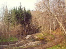
© Photo: Oberösterreich Tourismus GmbH./Robert Maybach: Enjoy the view in Upper Austria


Circular walking route Hofgraben


- Flatly
Interactive elevation profile
Create PDF
Tour-Details
Starting place: 4801 Traunkirchen
Destination: 4801 Traunkirchen
duration: 0h 35m
length: 2,2 km
Altitude difference (uphill): 28m
Altitude difference (downhill): 26m
Lowest point: 439m
Highest point: 467m
difficulty: easy
condition: easy
panoramic view: Great panorama
Paths covering:
Gravel, Hiking trail
powered by TOURDATA
Walking time: about 45 minutes - 1 hour
Highest point: 460 m
Route No.: 11
Starting point: Train station Traunkirchen
Pssibilities for refreshments: Restaurants in Traunkirchen Mitterndorf
Connection options:
● Connection to Elizabethruhe [route 10] approx. 25 min.
● Connection to Mühlbachberg and Hochsteinalm [route 12] approx. 2 h
● Possible connection via the sawmill grounds to the Buchberg area (running routes)
Most economical season
- Spring
- Summer
- Autumn
- Early winter
Please get in touch for more information.
Ortsplatz 1
4801 Traunkirchen
Phone +43 7617 2255
E-Mail gemeindeamt@traunkirchen.ooe.gv.at
Web www.traunsee.at
http://www.traunsee.at
Interactive elevation profile
Create PDF
Tour-Details
Starting place: 4801 Traunkirchen
Destination: 4801 Traunkirchen
duration: 0h 35m
length: 2,2 km
Altitude difference (uphill): 28m
Altitude difference (downhill): 26m
Lowest point: 439m
Highest point: 467m
difficulty: easy
condition: easy
panoramic view: Great panorama
Paths covering:
Gravel, Hiking trail
powered by TOURDATA