© Photo: Oberösterreich Tourismus GmbH./Robert Maybach: Enjoy the view in Upper Austria


Harrauloipe


- Suitable for families
- culinary interesting
- Flatly
- Possible accommodation
Interactive elevation profile
Create PDF
Tour-Details
Starting place: 4264 Grünbach
Destination: 4264 Grünbach
duration: 1h 18m
length: 6,0 km
Altitude difference (uphill): 67m
Altitude difference (downhill): 67m
Lowest point: 848m
Highest point: 898m
difficulty: easy
condition: medium
panoramic view: Great panorama
Paths covering:
snow
powered by TOURDATA
Trail not in operation
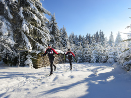
Cross-country skiing in the Freistadt region!
Both beginners and cross-country skiing pros can enjoy cross-country skiing on trails of various lengths, in classic or skating style.
At the Forellenwirt Kastler, you can warm up and fortify yourself after your sporting activity on the surrounding trails.
Harrauloipe: circular short trail - route: from the beginning like the house trail, but 2 km longer
Harraulo trail - 6 km - family trail, classic, double-tracked and easy
Information on the current trail situation can be found here: +43 (0)7942/72804
Starting point: Mitterbach 6 (Forellenwirt Kastler)
Destination: Mitterbach 6 (Forellenwirt Kastler)
further information:
- culinary interesting
- Flatly
- Possible accommodation
- Board possible
Details - Trail
- Nordic skiing facilities: Marked Nordic skiing run
- Type of Nordic skiing run: Classic style
- free
Accessibility / arrival
by car:
A1 to Linz - A7 to Unterweitersdorf, S10 to exit Sandl/Grünbach - roundabout 1st exit (direction Sandl) - B 38 to Schlag (approx. 500 m) - turn left to Grünbach.
By train:
Summerauerbahn to Freistadt or Summerau, 7 km to Grünbach
Trail car parks:
70 at Forellenwirt Kastler, 15 at St. Michael's Church
- Parking space: 85
- Suitable for groups
- Suitable for schools
- Suitable for teenagers
- Suitable for seniors
- Suitable for single travelers
- Suitable for families
- Suitable for friends
- Suitable for couples
- Deep winter
Please get in touch for more information.
")
Marktplatz 1
4264 Grünbach
Phone +43 7942 72813
E-Mail gemeinde@gruenbach.ooe.gv.at
Web www.gruenbach.ooe.gv.at
http://www.gruenbach.ooe.gv.at
Interactive elevation profile
Create PDF
Tour-Details
Starting place: 4264 Grünbach
Destination: 4264 Grünbach
duration: 1h 18m
length: 6,0 km
Altitude difference (uphill): 67m
Altitude difference (downhill): 67m
Lowest point: 848m
Highest point: 898m
difficulty: easy
condition: medium
panoramic view: Great panorama
Paths covering:
snow
powered by TOURDATA